Geology Exam 4
Study these flashcardsFree · spaced repetition · iPhone, Android, Mac & web
All cards
1
Residence time
The time water stays in a reservoir; varies among reservoirs (ex. shallow groudwater- 100 to 200 years; 10,000-20,000 years)
2
Tides Vs. Waves
Waves caused by wind, Tides caused by gravity
3
Where would you find highest surface water salinities?
Equatorial areas and restricted embayments of arid regions
4
Tides
Periodic rise and fall of large bodies of water due to gravitational interactions between moon, earth, and sun
5
Where does salt come from (that enters the ocean)?
Chemical compounds from land (weathering), chemical compounds from ocean (ex. deep sea vents), ions from volcanic eruptions (ex. sulfate)
6
Thermohaline circulation
Results in a global-scale conveyer belt that circulates water and controls climate
Because of this, the ocean mixes entirely in a 1,500 year period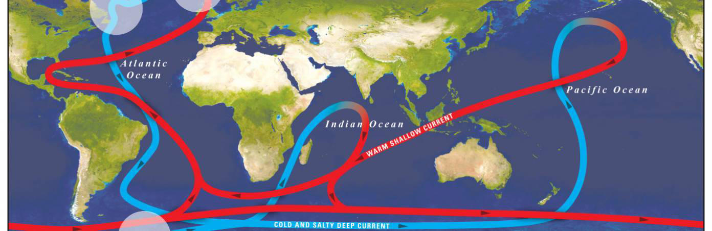
Because of this, the ocean mixes entirely in a 1,500 year period
7
What is salinity? Average salinity of the ocean?
Salinity is how much disssolved solids (ions) are in the water. ~3.5% or 35 ppt
8
Active margin? Passive margin?
1. Uplifted rocky coasts dominate
2. Broad, low-lying coastal plains typical; less siesmic activity
2. Broad, low-lying coastal plains typical; less siesmic activity
9
What percentage does the ocean take up of earth?
71%
10
How much of the planet's water does the ocean contain?
More than 97%
11
Average depth of the ocean?
4 km
12
Natural barriers to protect shorelines?
Dunes (w/ or w/o vegetation), vegetation (ex. mangroves, and sea grass), and coral reefs
13
Types of shorelines? What effects shoreline?
1. Coral reefs, sandy, rocky, coastal wetlands
2. Waves, tides, currents, humans
2. Waves, tides, currents, humans
14
What causes water density to increase? What happens to the denser water? Example?
Higher salinity and colder temperature. Water sinks. Ex. N. Atlantic cold deep current.
15
Under what conditions will a glacier retreat?
Low glacial flow and high temperatures
16
Where water is stored on Earth (reservoirs)?
Ice (ex. ice caps, glaciars), shallow and deep groundwater, oceans and inland seas, freshwater bodies (rivers, streams, lakes), snow, living things, atmospheric water vapor
17
Landscape
The character and shape of the land surface in a region
18
Landforms
The individual shapes (valleys, cliffs, beaches, etc.) that make up landscapes.
19
Landscapes of the Moon
-Shaped by ancient meteorite impacts and volcanic eruptions
-No plate tectonics, No new mountains or volcanoes, No hydrologic cycle, No erosion from rivers, wind, or ice
-No plate tectonics, No new mountains or volcanoes, No hydrologic cycle, No erosion from rivers, wind, or ice
20
Digital Elevation Models (DEM)
Detailed digital data sets of elevation variations produced by radar imaging
21
Relief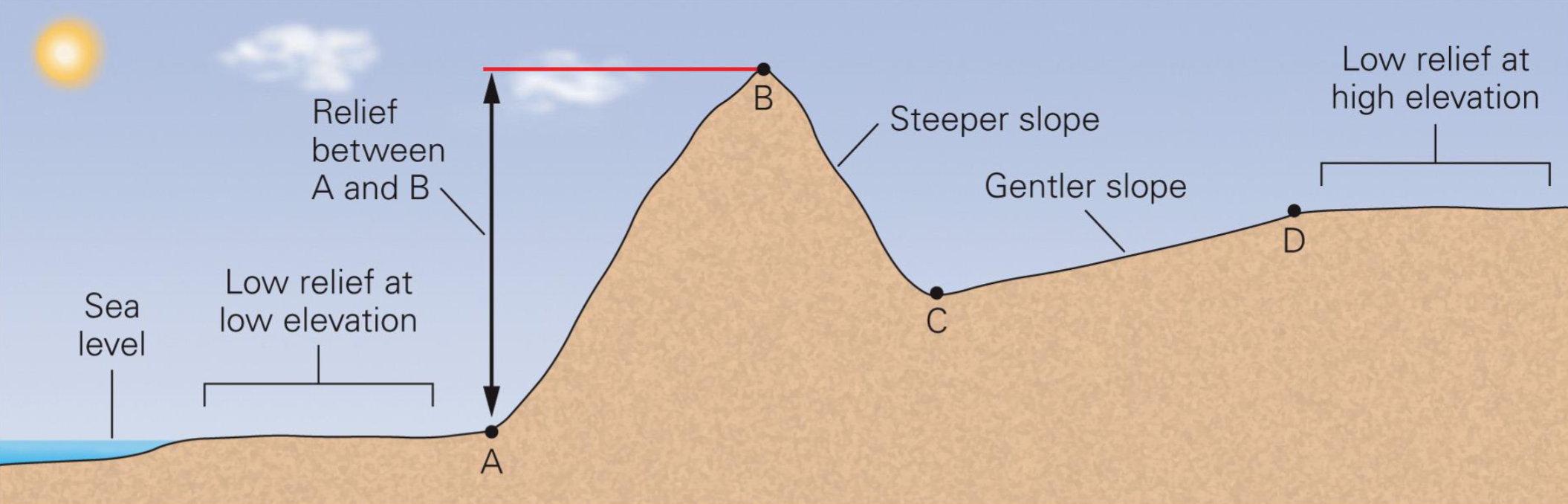
The elevation difference between two points separated by a specific horizontal distance.
22
Topography
The variation in land surface elevation
23
Importance of water erosion
-Agricultural development is often reliant on the nutrient-rich soils created by the accumulation of eroded earth
-Helped feed water sources with essential nutrients, helping the local aquatic ecosystem.
-Shape the land
-Helped feed water sources with essential nutrients, helping the local aquatic ecosystem.
-Shape the land
24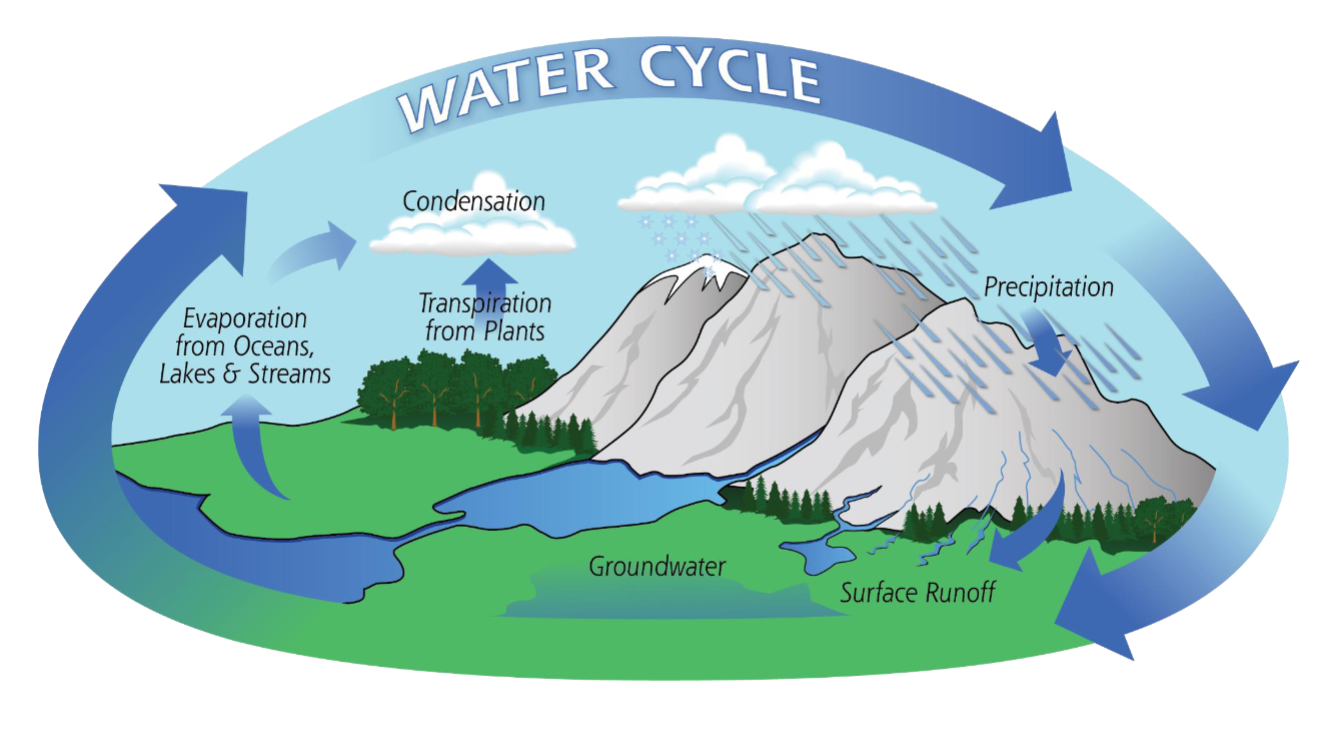
Draw the hydrologic cycle and the water cycle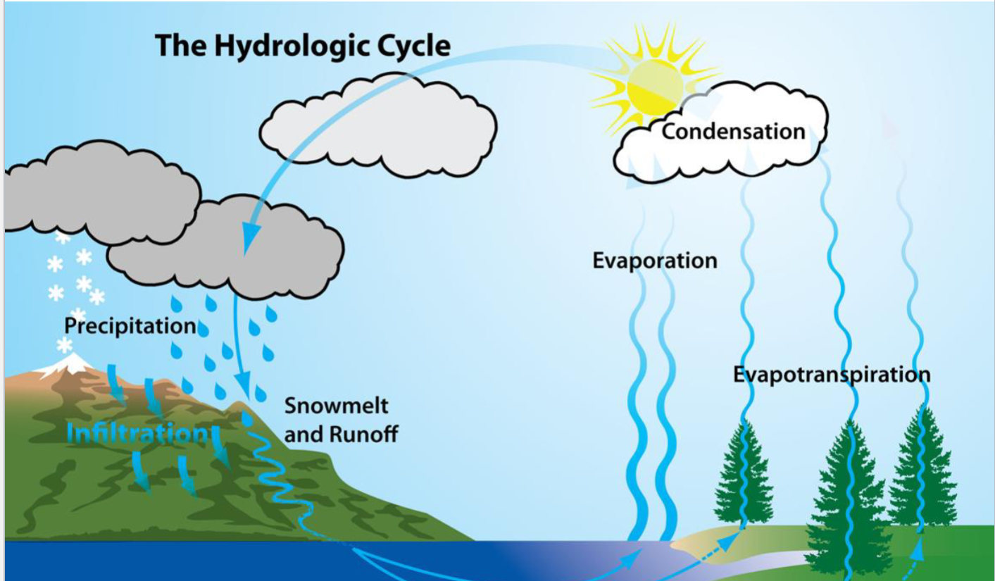
25
Total water on earth percentages
97% Saline, 3% Freshwater
26
Alluvium
Sediment that has been deposited by running water (rivers and streams)
27
Channel
A trough dug into the ground surface by flowing water
28
Trunk stream
The main branch of the stream
29
Tributaries
The smaller branches that feed the main branch
30
How does water end up in a river?
Evapotranspiration, Precipitation, Runoff (sheetflow), Throughflow from soil moisture, Groundwater
31
Natural nuildup along a stream that helps prevent future flooding?
Levee
32
A flooded valley that was originally formed by glaciers?
Fjord
33
Stream Initiation
1. Sheet flow erodes substrate and creates rills
2. A new channel starts to form and carves into the substrate
3. Eventually, flow is concentrated in a single channel.
4. Tributaries develop and drainage network forms
2. A new channel starts to form and carves into the substrate
3. Eventually, flow is concentrated in a single channel.
4. Tributaries develop and drainage network forms
34
Rill vs Gully
1. a trickle of water, a very small stream; ephemeral
2. a small watercourse with steep sides, usually cut into soil
2. a small watercourse with steep sides, usually cut into soil
35
How does the channel grow longer?
-Downcutting and erosive power of surface flow (extends downstream)
-Groundwater sapping
-Groundwater sapping
36
What drainage pattern is this?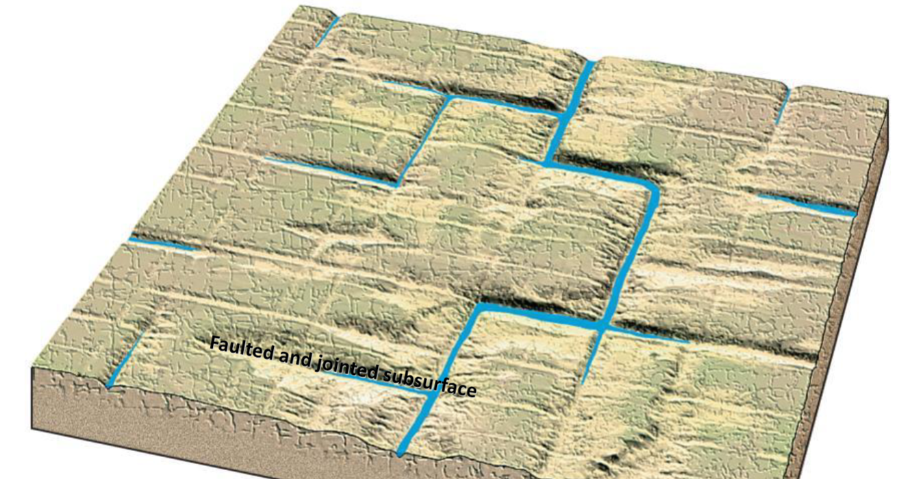
-Rectangular drainage: A highly fractured and jointed surface will result in streams that meet at high angles.
-Not common in nature
-Not common in nature
37
What drainage pattern is this?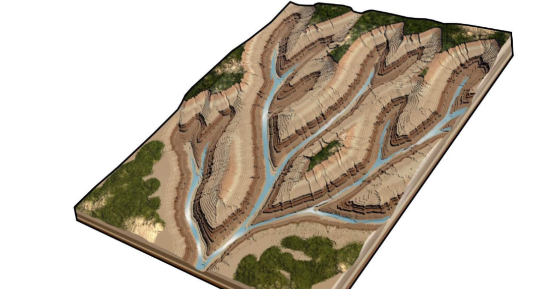
Dendritic
-Most common !
-Uniform substrate and uniform initial slope
-Most common !
-Uniform substrate and uniform initial slope
38
What drainage pattern is this?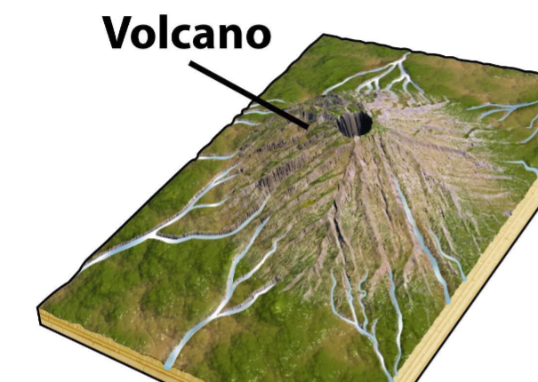
Radial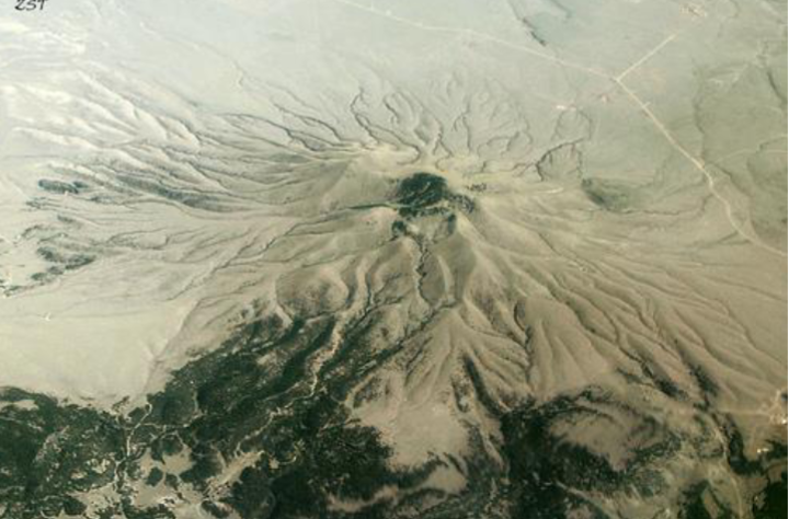
39
What drainage pattern is this?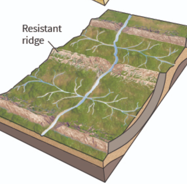
Trellis
40
What drainage pattern is this?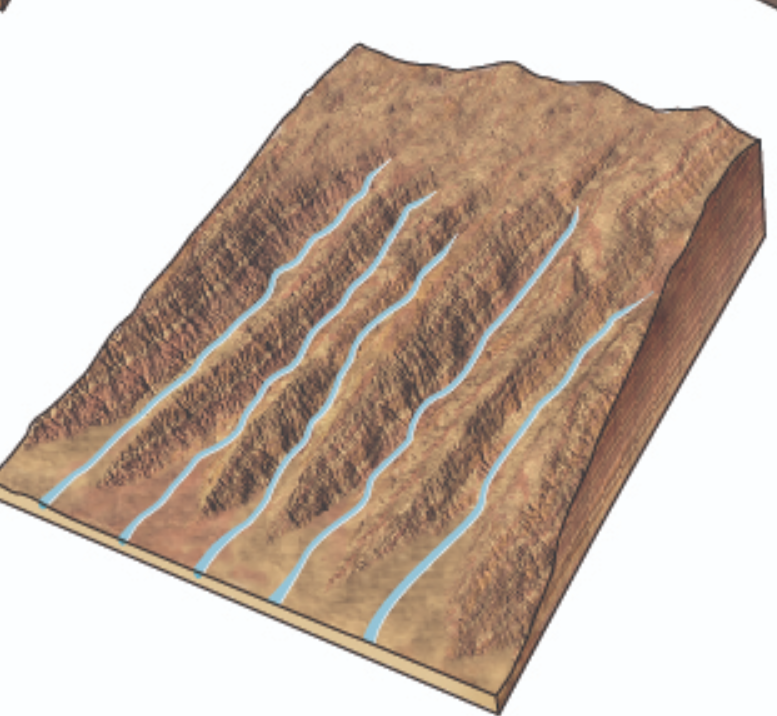
Parallel
41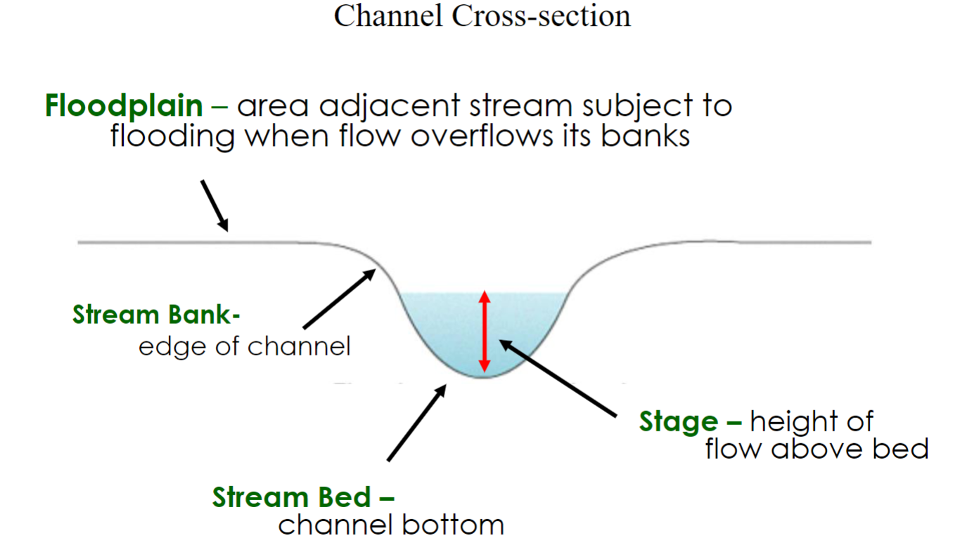
Draw basic stream anatomy
42
What stream morphology is this?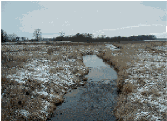
Straight
-Rare in nature
-Upper course (headwaters)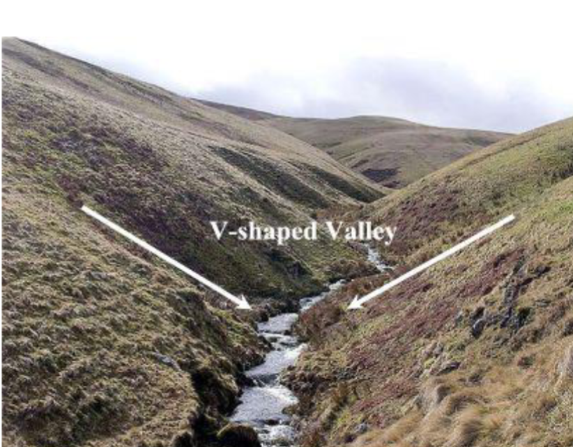
-Rare in nature
-Upper course (headwaters)
43
Caves
underground cavity formed by dissolution by groundwater (contain speleothems)
-form when calcium carbonate degasses from dripping or flowing water in a cave
-form when calcium carbonate degasses from dripping or flowing water in a cave
44
Karst. Why are they important?
1. Landscape dominated by features formed from limestone dissolution by freshwater (often groundwater including caves and sinkholes)
2. They provide porous groundwater aquifers
2. They provide porous groundwater aquifers
45
What stream morphology is this?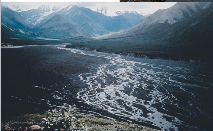
Braided
-Middle course; Gravel and sand bars; “Braids” of sediment
-Needs high sediment load and high - medium gradient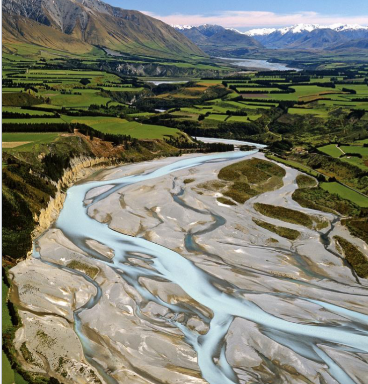
-Middle course; Gravel and sand bars; “Braids” of sediment
-Needs high sediment load and high - medium gradient
46
What stream morphology is this?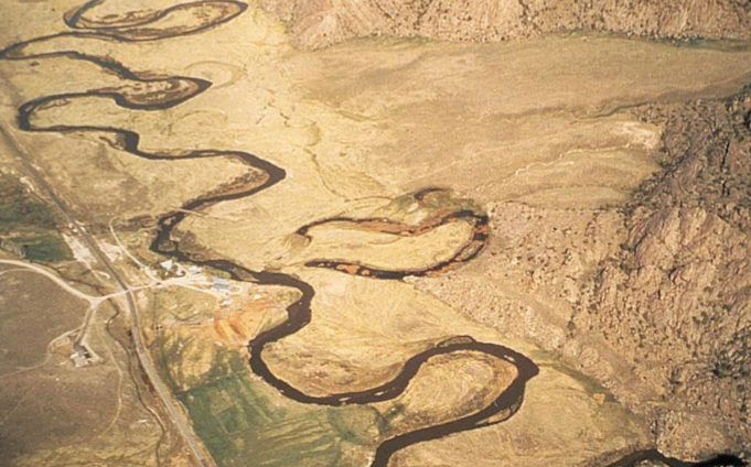
Meandering
-Lower course; Most common type of river channel
-Needs high sediment load and low gradient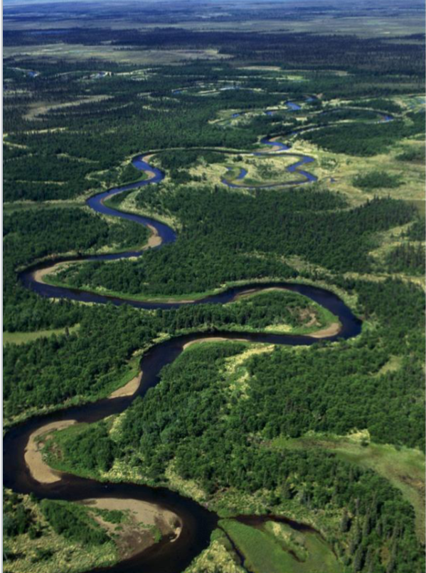
-Lower course; Most common type of river channel
-Needs high sediment load and low gradient
47
What can impact stream morphology?
Bedrock and structures and sediment load
Slope changes downstream too
Slope changes downstream too
48
Whic is the cut bank, which is the point bar?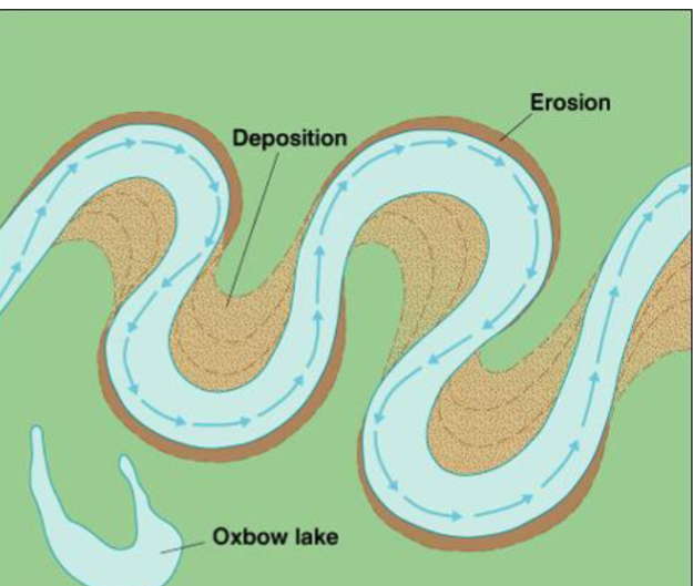
Cut bank: erosion
Point bar: deposition
Point bar: deposition
49
–Dissolved load – ions in solution from weathering
–Suspended load – fine particles (make water look ‘muddy’)
–Bed load - Moves during high velocity events along the bottom of the stream
------Sandy Portion – Saltation (bouncing)
------Cobbles – Traction (rolling)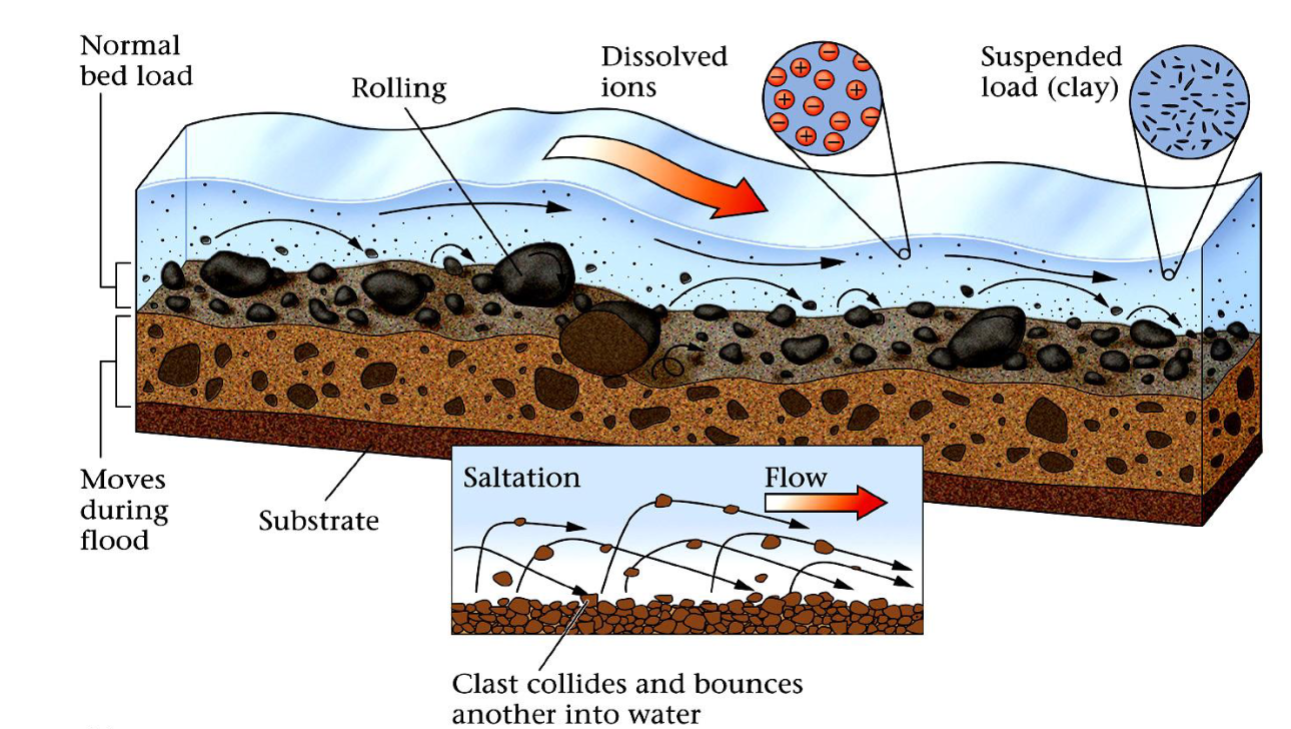
Sediment loads and what they mean
–Dissolved load – ions in solution from weathering
–Suspended load – fine particles (make water look ‘muddy’)
–Bed load - Moves during high velocity events along the bottom of the stream
------Sandy Portion – Saltation (bouncing)
------Cobbles – Traction (rolling)
50
How is energy converted in a river? How much is lost and why? And what is the remaining used for?
Conversion of Potential energy (elevation) to Kinetic Energy (motion). Most energy lost to friction, but 2-4% of total potential energy converted to work of erosion and transportation of sediments
51
What happens to sedimets at high and low velocity?
High velocity: sediments are eroded
Low velocity: sediments are deposited
Low velocity: sediments are deposited
52
Permanent vs Ephemeral streams
1. water flowing all year, common where there is abundant rainfall, groundwater discharge, and low rates of evaporation
2. do not flow all year common in places with low annual rainfall, a low water table, and high rates of evaporation
2. do not flow all year common in places with low annual rainfall, a low water table, and high rates of evaporation
53
Porosity vs Permeability. What gives rocks these features?
1. Porosity-ability to hold water (total volume of open pore space in the rock); Small open spaces
-Porosity can be filled with water or air; Pores can become filled with mineral cement and other fluids, like oil or natural gas.
2. Permeability- Measure of interconnectedness of the pore spaces (ie. connected pores)=ease of water flow
-Ability of fluids to pass through pores; Depends on “connectivity” -> Well-connected = high permeability
-Porosity can be filled with water or air; Pores can become filled with mineral cement and other fluids, like oil or natural gas.
2. Permeability- Measure of interconnectedness of the pore spaces (ie. connected pores)=ease of water flow
-Ability of fluids to pass through pores; Depends on “connectivity” -> Well-connected = high permeability
54
Water table. Is it variable or static? Saturated and unsaturated zones. Topographical info.
1. The water table is the top of the groundwater reservoir.
2. The water table rises and falls seasonally with variation in rainfall and infiltration
3. unsaturated (vadose) zone above the water table = air and water in pores
4. saturated (phreatic) zone below the water table “aquifer” = water fills pores
5. The water table mimics surface topography: Water flows from higher elevations to lower elevations underground
2. The water table rises and falls seasonally with variation in rainfall and infiltration
3. unsaturated (vadose) zone above the water table = air and water in pores
4. saturated (phreatic) zone below the water table “aquifer” = water fills pores
5. The water table mimics surface topography: Water flows from higher elevations to lower elevations underground
55
Aquifer vs Aquitard, and rock e
1. sediments or rocks that transmit water easily (ex. Limestone, lightly cemented sanstone)
2. (confining bed) – sediment or rock that does not transmit water easily (ex. Granite, schist)
2. (confining bed) – sediment or rock that does not transmit water easily (ex. Granite, schist)
56
Unconfined vs confined aquifer
1. lies at the surfac; in contact with human activities, it is easily contaminated.
2. lies beneath an aquitard; isolated from the surface, it is less susceptible to pollution.
2. lies beneath an aquitard; isolated from the surface, it is less susceptible to pollution.
57
What else can make aquifers?
sand, coarse grained sediments, fractured bedrock, caves/karst
58
Cone of Depression
Pumping from a well in a water table aquifer lowers the water table near the well
-Pumping groundwater affects the water table. If groundwater is extracted faster than it can be replaced, a cone of depression develops around the well.
-Pumping groundwater affects the water table. If groundwater is extracted faster than it can be replaced, a cone of depression develops around the well.
59
Where can you find glaciers?
High latitudes (polar regions)
• Continental glaciers:
• Ice caps / ice sheets
High altitudes
• Mountain Glaciers (Alpine glaciers)
-Cirque glaciers, Valley glaciers, Piedmont Glaciers
• Continental glaciers:
• Ice caps / ice sheets
High altitudes
• Mountain Glaciers (Alpine glaciers)
-Cirque glaciers, Valley glaciers, Piedmont Glaciers
60
How to make a glacier?
Low temperatures, Sufficient snow fall to accumulate large amounts, gentle enough slope (glaciers do flow)
61
Movement mechanisms
1. Dry-Based Glaciers- so cold that there is no liquid water present-> move by internal plastic deformation of ice
2. Wet-Based Glaciers- move by basal sliding of the ice over a film of meltwater or water-saturated sediment
2. Wet-Based Glaciers- move by basal sliding of the ice over a film of meltwater or water-saturated sediment
62
Can glaciers effect landscape?
Yes, such as jagged mountain tops caused by glaciers, and chnage in valley shapes
1.Before glaciation, valleys are V-shaped, and tributary mouths are the same elevation as the trunk streams
2. During glaciation, the valleys fill with ice and are aggressively eroded and steepen dramatically
3. After glaciation, the landscape is transformed, containing U-shaped valleys, hanging valleys, cirques, arêtes, horns, and other evidence of the erosive power of glaciers.
1.Before glaciation, valleys are V-shaped, and tributary mouths are the same elevation as the trunk streams
2. During glaciation, the valleys fill with ice and are aggressively eroded and steepen dramatically
3. After glaciation, the landscape is transformed, containing U-shaped valleys, hanging valleys, cirques, arêtes, horns, and other evidence of the erosive power of glaciers.
63
(Basically) how does a glacier form?
A layer of snow can be compacted like a sediment, the preexisting ice recrystalizes in a solid state
64
Zone of accumulation, zone of ablation, and equilibriu
1. Zone of accumulation- Top of glacier (glacier is growing)
2. Zone of ablation- where glacier can recede (lower on the glacier, but before the terminus/toe
3. Equilibrium- Between the two zones
2. Zone of ablation- where glacier can recede (lower on the glacier, but before the terminus/toe
3. Equilibrium- Between the two zones
65
Processes of glacial ablation
-Sublimation (ice evaporates into the air)
– Melting (ice melts into liquid)
– Calving (ice breaks off at the toe)
– Melting (ice melts into liquid)
– Calving (ice breaks off at the toe)
66
Crevasses
brittle upper layer of a glacier-cracks (can be very big)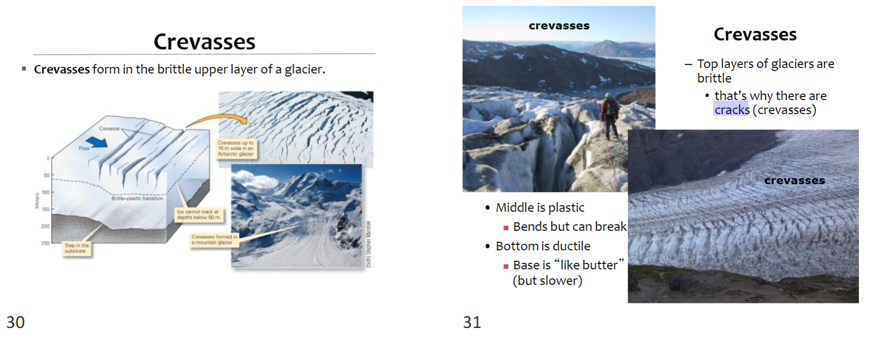
67
Glatial deposition
Glaciers can accumulate and move sediments
Material transported to the toe (bottom/end of a glacier) piles up as an end moraine->material is called glacial till
Can contain variety of rocks/sediments, poorly sorted, un-stratified, and any size/shape
Material transported to the toe (bottom/end of a glacier) piles up as an end moraine->material is called glacial till
Can contain variety of rocks/sediments, poorly sorted, un-stratified, and any size/shape