Aviation Meterology 2
Study these flashcardsFree · spaced repetition · iPhone, Android, Mac & web
All cards
1
Select the factor which is not related to forming the thunderstorms?
- sufficient water vapor,
- Strong wind
- a lifting mechanism
- unstable air,
2
When the cell transitions to the mature stage?
- Starting of precipitation
- Starting to show anvil top
- Maxmum growth rate of the clouds
3
The distinguishing feature of the towering cumulus stage is?
- lightning and thunder
- strong convective updraft
- precipitation start
4
Weather hazards reach peak intensity toward the end of the __________
- mature stage.
- dissipating stage
- cumulus stage
5
Where is the windshear associated with thunderstorm.
- On all sides, underside, and inside of the thunderstorm
- anvil side (front) fof the thunderstorm
- right under the thunderstorm
6
Which stage of thunderstorm associated with strong downdraft embedded within the area of precipitation ?
- Mature
- Cumulus
- Dissipating
7
If severe turbulence is encountered nearby or in the thunderstorms, the airplane should be slowed to the __________speed otherwise excess load that can be imposed on the wing.
Va
8
Maximum downdrafts in a microburst can be as strong as
- 6,000 feet per minute
- 10,000 feet per minute
- 8,000 feet per minute
9
An aircraft experience microburst headwind of 45 knots, the total decrease in speed would be;
45 knots
10
During ILS approach, if an aircraft encounter windshear, first tailwind then headwind, what should a pilot do with power
- Increase power then reude
- Maintain constant power
- reduce power then increase
11
While flying an ILS, a constant tailwind shears to a calm wind. What will the pilot observe?
- Airspeed and pitch attitude increase and then airplane will go below glide slope.
- Airspeed and pitch attitude increase and and then airplane will go above glide slope.
- Airspeed and pitch attitude decrease and then airplane will go below glide slope.
12
During an ILS constant IAS is maintained, if you encounter windshear from headwind to tailwind what will happen?
- A. PITCH ATTITUDE: Increases then decrease; REQUIRED THRUST: Increased, then reduced; VERTICAL SPEED: Increases; IAS: Increases, then decreases
- PITCH ATTITUDE: Decreases then increase; REQUIRED THRUST: Increased, then reduced; VERTICAL SPEED: Increases; IAS: Decreases, then increases.
- PITCH ATTITUDE: Increases then decrease; REQUIRED THRUST: reduced, then increased; VERTICAL SPEED: increase then decreases; IAS: increase, then decreases
13
Which is correct statement regarding turbulence associated with thunderstorms?
- Outside the cumulonimbus cloud, turbulence has been encountered several thousand feet above, and 20 miles laterally from, a severe storm.
- Outside the cumulonimbus cloud, turbulence has been encountered several thousand feet above, and 40 miles laterally from, a severe storm.
- Outside the cumulonimbus cloud, turbulence has been only encountered several thousand feet above, and 5 miles laterally from, a severe storm.
14
What are visible indications of extreme turbulence in thunderstorms?
- shelf cloud, very frequent lightning, and roll clouds.
Low ceiling and visibility, hail, and precipitation static.- icing, steady rain, and hail.
15
An aircraft experience microburst headwind of 45 knots, the total decrease in speed would be;
- 45 knots
- 120 knots
- 90 knots
16
The decrease of the intensity of energy within the radar beam due to absorption or scattering of the energy from precipitation particles. Because of this distant targets (i.e., precipitation) behind of nearer target may not be displayed on a radar image. This is called as:
precipitation attenuation,
17
if the aircraft weather radar shows intensive thunderstorm echoes, this echoes should be circumnavigated by maintaining a minimum distance of
20 miles
18
Select the radar abnormalities that reflect lesser energy
- Super refracttion
- liquid cloud-sized particles
- Bright Band
- liquid precipitation sized particle
19
Select true statement:
- Larger particles have lesser reflectivity than smaller particles
- When attenuation occurs, the radar beam will hit the surface of the Earth, causing some of the beam's energy to backscatter
- liquid precipitation-sized particle reflectivities are weaker than liquid cloud-sized particles.
- A radar image cannot reliably be used to determine the intensity of snowfall
20
Anomalous Progagation (AP) is?
- weak reflectivity
- lack of beam resolution
- When ducting occurs, the radar beam will hit the surface of the Earth causing some of the beam's energy to backscatter
- False echoes due to attenuation
21
the ability of the radar to identify targets separately (large ground radar is better at the same range) is called:
- Beam resolution
- Precipitation attenuation
- range attenuation
22
Which is recommended procedures when if a pilot entered in an embedded thunderstorm unintentionally?
- Reduce airspeed to just below maneuvering speed and maintiain a constant altitude
- Turn aircraft back where it came from as it should be better then current conditions.
23
What happens above Arctic Circle latitude?
- There are no Twilight.
- Any point north of the Arctic Circle has spring and days when the sun stays below the horizon all day
- number of these days decrease toward the North Pole.
- Any point north of the Arctic Circle has fall and winter days when the sun stays below the horizon all day
24
In Arctic during summer afternoons, scattered cumulus clouds forming over the interior occasionally grow into thundershowers. These thundershowers move generally to which direction
- to the northwest.
- from northeast to southwest
- from southwest to northeast
- to northeast as mid latitude thunderstorms.
25
What is not the airmass characteristic in Arctic winter?
- very low humidity
- Very cold
- moist and cold
- strong temperature inversion
26
How the Solar flares affect aviation?
- visibility reduction
- Brighten aurora
- difficulty in HF communications
- difficulty in UHF communications
27
BL(PVT) Which briefing should be requested when a planned departure is 6 or more hours away?
- an abbreviated briefing.
- a supplementary briefing.
- an outlook briefing.
28
Which briefing should be requested to update a previous weather briefing?
- an abbreviated briefing.
a standard briefing.
an outlook briefing.
29
Which type of weather briefing should a pilot request to supplement mass disseminated data?
- an abbreviated briefing.
a standard briefing.
an outlook briefing.
30
BL (COMM) For an IFR flight, which source should be used to obtain the most current condition and en route and destination weather forecas
- Flight service.
- Any internet briefing sources including Aviation Weather Service and National Weather Service.
- DUATS and Telephone Information Briefing Service (TIBS)
31
Weather Advisory Broadcasts, SIGMETs, and Convective SIGMETs, (Not applicable to HIWAS : of which broadcasts are only a summary of the information, and pilots should contact an FSS for detailed information) are also provided by
- on all communications/NAVAID frequencies
- Flight Service on 122.2 MHz and selected VORs
- ARTCCs on their frequencies
32
Who is the certified weather observer that can provide official weather.
- ARTCC(center) controller
- TRACON(approach) controller
- FSS (flight service) briefer
- ATCT (tower) controller
33
The best way is to get a weather briefing is to call FSS and request Standard Briefing. Alternatives are available via the internet. The two best methods is to use:
Question 14 options:
Question 14 options:
- Any internet where NOTAM is available
- www.12800wxbrief.com or ADDS (aviation digital data service)
- Any internet weather information as long as it came from reliable sources
- TIBS, DUATS
34
What are the weather information sources for those pilots already in flight?
- WXBRIEF
- DUATS, ADD
- HIWAS, FSS, FIS-B, ATC
- ADD and LEIDOS
35
Intertropical Convergence Zone (ITCZ).(i.e.Doldrums) is located:
- at the sub-polar region
- the vicinity of the Equator
- at the subtropical high pressure belts
- at the polar region
36
Southwest U.S. is dominated in summer by a subtropical high, and South East U.S weather where convection can penetrate the weak inversion, and showers and thunderstorms often develop in summertime. These are due to
- subtropical low
- subtropical high
ITCZ (doldrums)- monsoon
37
In mid northern latitude, northeast side of island get frequent rainfall whereas opposite side are semiarid. This is because of:
- monsoon
- doldrums
- subtropical high
- trade winds
38
Select the answer which is least related to monsoon:
- This is large scale seasonal wind shift .
- Extensive cloudiness, copious rain, and numerous thunderstorms.
During the summer, the low over central Asia draws warm, moist, and unstable maritime air from the southwest over the continent.- Under a subtropical high receives very little rainfall because of the persistent temperature inversion.
39
Transitory Systems such as Sheer line, Tropical Upper Tropospheric Trough (TUTT), Tropical Wave. West African Disturbance Line (WADL) are breeding ground for:
- Tropical Cyclones
- Monsoon
- Trade wind
- Dry weather
40
Select incorrect statement regarding tropical cyclones:
- On land, warm air flowing into the storm gradually weakens it.
A hurricane system must also have horizontal outflow (divergence) at high tropospheric levels.
Tropical cyclones are unlikely within 5° of the Equator because the Coriolis force is so small
As these storms move toward the mid-latitudes, they come under the influence of the prevailing westerlies.
41
The FAA ________ system provides pilots and flight crews of properly equipped aircraft with a cockpit display of certain aviation weather and aeronautical information.
- Flight Information Service-Broadcast (FIS-B)
- Traffic Information Service – Broadcast (TIS−B)
- Universal Access Transceiver (UAT).
Extended squitter (1090ES)
42
Pilots on IFR flights trying to relying on ATC in-flight weather avoidance assistance should concern that
-
ATC will provide weather radar service only in the en route areas away from congested terminals
ATC has no capacity to check the intensity of weather and other weather warnings.
ATC radar limitations and workload, frequency congestion may restrict the controller's capability to provide weather service
43
If A Weather report shows follows What is the maximum altitude to maintain VFR below the ceiling in Class E airspace (field elevator KHOB 3660) : METAR: KHOB 101110Z, 18004KT 5SM BKN025 OVC050 14/5 A2992
- 3,000 feet AGL.
- 2,000 feet AGL.
- 2,500 feet AGL.
44
BL What is sky condition in this METAR observation?
METAR KOKC 011955Z AUTO 22015G25KT 180V250 3/4SM R17L/2600FT +SN BLSNFG VV008 00/M03 A2992 RMK RAE12SNB12
METAR KOKC 011955Z AUTO 22015G25KT 180V250 3/4SM R17L/2600FT +SN BLSNFG VV008 00/M03 A2992 RMK RAE12SNB12
- Runway 17L Ceiling is 2600 feet
- Sky is obscured with vertical visibility of 800 feet
- Measured ceiling is 800 feet overcast
45
What does remarks section of METAR surface report?
METAR KOKC 011955Z AUTO 22015G25KT 180V250 3/4SM R17L/2600FT +SN BLSNFG VV008 00/M03 A2992 RMK RAE12SNB12
METAR KOKC 011955Z AUTO 22015G25KT 180V250 3/4SM R17L/2600FT +SN BLSNFG VV008 00/M03 A2992 RMK RAE12SNB12
- The wind is variable from 180° to 250
- Rain ended 12 past the hour, snow began 12 past the hour.
- Heavy blowing snow and fog on runway 17L.
46
BL OKC has a field elevation of 1,300 feet MSL. what is its thickness (Tops of OVC are ported at 4000 feet MSL)of the overcast layer?
SPECI KOKC 011955Z AUTO 22015G25KT 180V250 3/4SM R17L/2600FT +TSRA BR BKN008 OVC010 18/16 A2992 RMK AO2 TSB25 TS OHD MOV E SLP132
SPECI KOKC 011955Z AUTO 22015G25KT 180V250 3/4SM R17L/2600FT +TSRA BR BKN008 OVC010 18/16 A2992 RMK AO2 TSB25 TS OHD MOV E SLP132
- 700
- 1,700
- 1,000
47
In METAR for KOKC means?
METAR KOKC 011955Z AUTO 22015G25KT 180V250 3/4SM R17L/2600FT +TSRA BR OVC010CB 18/16 A2992 RMK AO2 TSB25 WSHF 30 FROPA SLP132
METAR KOKC 011955Z AUTO 22015G25KT 180V250 3/4SM R17L/2600FT +TSRA BR OVC010CB 18/16 A2992 RMK AO2 TSB25 WSHF 30 FROPA SLP132
- Thunderstorm Rain and mist obstructing visibility; Thunderstorm base 2500 feet Wind shift 30 knots due to frontal passage.
- Visibility limited 180 to 250, 3/4 S. miles. Thunderstorm brought Rain shower and mist. Windshift at 30 knots from pressure altitude 1013.2
- Thunderstorm Rain and mist obstructing visibility; Thunderstorm began at 1925Z. Wind shift 1930 due to frontal passage.
48
BLM A ceiling is defined as the height of the
- lowest layer of clouds that contributed to the overall overcast
- the lowest layer aloft reported as broken or overcast
- the highest layer aloft reported as broken or overcast
49
in-flight icing should be reported as?
- Few, light, moderate, severe.
- Trace, light, moderate, severe
- Occasional, light, moderate, servere, extreme.
50
Reflectivity is also correlated with intensity terminology (phraseology) for air traffic control (ATC) purposes. WSR-88D Weather Radar Precipitation Intensity Terminology, defines this correlation.
- occasional, light, moderate, heavy
- light, moderate, heavy, extreme
- light, moderate, heavy, severe
51
Select incorrect statement:
- NEXRAD radar data data-linked to aircraft cockpit displays via FAA Flight Information Service-Broadcast (FIS-B) use the Base Reflectivity data for their radar mosaics
- Precipitation at any location may be heavier than depicted on the Base Reflectivity image because it is occurring above the lowest elevation angle.
- Composite Reflectivity is the maximum echo intensity (reflectivity) detected within a column of the atmosphere above a location.
- NWS radar mosaic sectors may be assembled using only Base Reflectivity data.
52
Airborne weather radar is to
avoid severe weather
53
What is Terminal Doppler Weather Radar (TDWR) for?
- used for remote area to detect thunderstorm.
- used primarily for the detection of hazardous windshear conditions, precipitation, and winds aloft on and near major airports
- used to look for high- altitude phenomena
- used to find out hail size.
54
How would pilots know there are Windshear/Microbust nearby the airport he/she is making a approach utilizing TDWR(Terminal Doppler Weather Radar), LLWAS (Low level wind shear), WSP (Weather System Processor) and ITWS (Integrated Terminal Weather System)?
- By using onboard RARAR.
- ATC controller will advise.
- by using ACARS and the company will send a message.
- by asking FSS
55
What is the wind on the above shown Interactive Display Station Plot Example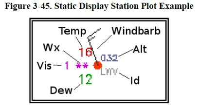
- Wind from North North West 15 knots.
- Wind from South South East 15 knots
- Wind from North North West 30 knots
- Wind from South South East 30 knots
56
What is the sky condition of the above Interactive Display Station Plot Example. 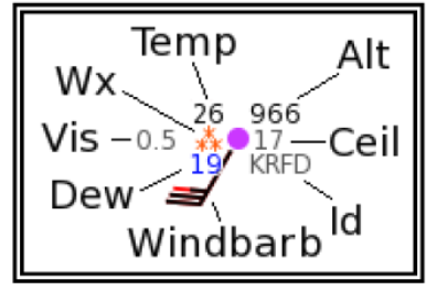
- Overcast Ceiling 1,700 feet
- Broken Ceiling 1,700 feet
- Obscured Top 1,700 feet
- Obscured Visibility 170 feet
57
(BL) The Surface Analysis Charts are to show:
- Forecasted at the valid time, the positions of highs, lows, ridges, and troughs; the location and type of fronts.
- At the valid time actual distribution of sea-level pressure; the positions of highs, lows, ridges, and troughs; the location and type of fronts; and the various boundaries such as drylines.
- Wind aloft and temperature, Jetstream altitude and location, and tropopause height.
- At the valid time actual cloud coverage and ceiling: height of top of the cloud, frontal movement,
58
(BL 21-2) On a Surface Analysis Chart, the solid lines indicate:
- Field elevation pressure isobars
- Seal level isotach (equal wind speed)
- Field elevation Isotemp (equal temperature)
- Sea level pressure isobars.
59
(BL21-3) On a surface analysis chart, the dashed lines indicate
- Dryline
- Squall line
- Ridge
- Trough (Trof)
60
(BL21-4) On a Surface Analysis Chart, closely spaced isobars over the area indicate?
- Weak wind along the isobar
- Large temperature change along the isobar
- Large pressure change across the area
- Small pressure change across the area.
61
BL21-5 Isobars on a surface weather analysis charts represent lines of equal pressure:
- reduced to sea level
- at the field elevaton
- at a specified pressure altitude
62
BL21-7) On the weather charts, the following symbols indicate:
- Rain and hail
- Freezing rain and sleet
- Light Rain and shower
- Light Snow and snow shower
63
What is the height of the 500 millibar level at the low pressure center in U.S.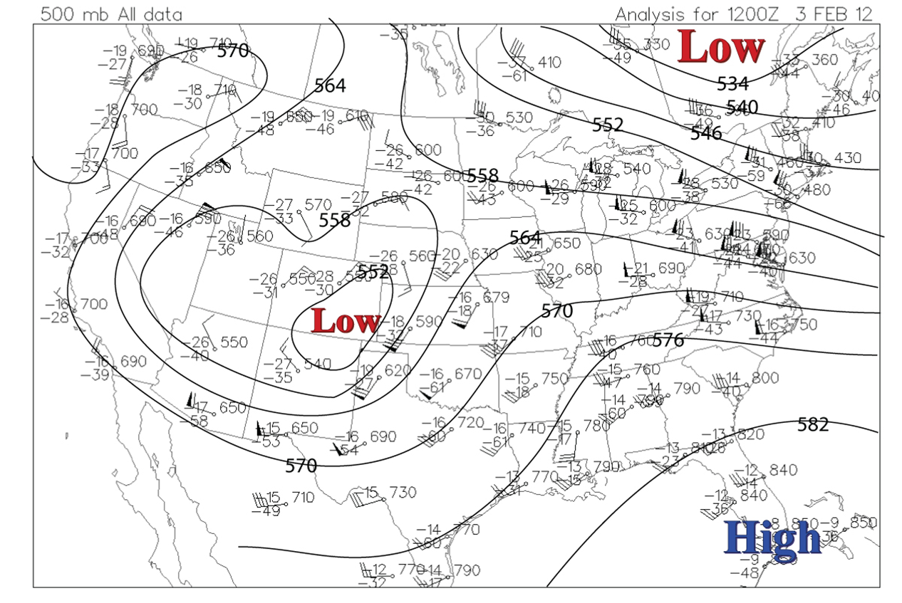
- 5520 meter AGL
- 5520 feet MSL
- 5520 meter MSL
- 18,590 feet MSL
64
AIRMETs in CONUS are issued
- Every six hours
- 15 minutes after every three hours
- 45 minutes after every hour.
65
AIRMETs are valid to maximum?
- Six hours
- three hours
- nine hours
66
________ may be issued when any of the following weather phenomena are occurring or are expected to occur. Moderate icing, moderate turbulence, winds of 30 knots or more at the surface and widespread mountain obscuration?
- AIRMETs and Center Weather Advisories (CWA).
- Convective SIGMETs and SIGMETs.
- Severe Weather Forecast Alerts (AWW) and SIGMETs.
67
Select the incorrect statement about AIRMET
- An AIRMET may be issued when Moderate turbulence, Moderate icing or Widespread mountain obscuration expected.
- AIRMETs are issued every hour.
- AIRMETs are intended for dissemination to all pilots in flight to enhance safety and are of particular concern to operators and pilots of aircraft sensitive to the phenomena described and to pilots without instrument ratings.
- An AIRMET may be issued when Ceiling less than 1,000 ft and/or visibility less than 3 statute miles (sm) (IFR).
68
Center Weather Advisory will be issued when:
- There is existing AWC (Aviation Weather Center) or AAWU (alaska) advisory in effect.
- conditions meeting or approaching national in-flight advisory (AIRMET, SIGMET, or Convective SIGMET) criteria exist
- anytime PIREP is reported.
- Light turbulence is reported
69
Who issues Center Weather Advisory (CWA)?
- National Oceanic and Atmospheric Administration (NOAA).
- Center Weather Service Unit responsible for the ARTCC service area.
- National Weather Service (NWS)
- Pilots flying in ARTCC service area
70
(PVT and INST, COMM BLM) Which product provide the necessary aviation weather information to give users a complete picture of the weather that may impact flights in the CONUS (especially the airport where TAF is not available)
- Surface analysis
- Radar observations
- Satellite observations
- Graphical Forecasts for Aviation (GFA)
71
(BLM INST) What is thehe precipitation type forecasted over southern ND (area C)?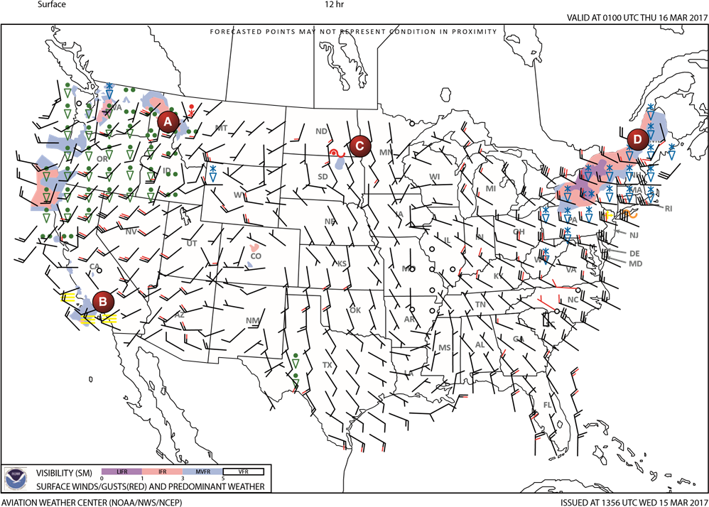
- Freezing drizzle
- Moderate snow
- Freezing rain
72
What is predominant type of precipitation throughout Washington (A)?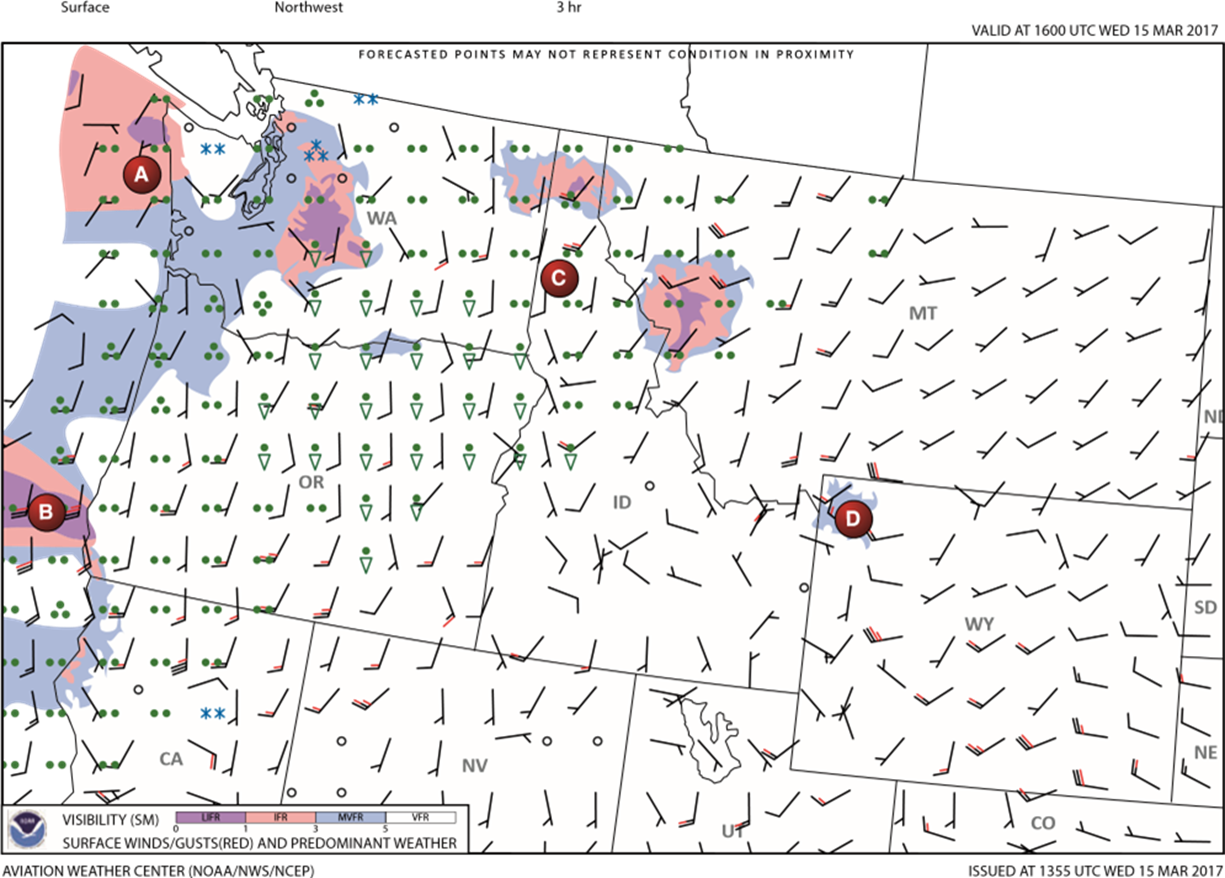
- Sleet and Freezing rain
- Heavy snow and rain showers
- Light rain and rain showers
73
BLM Visibility of the state of Washington (Area A) is;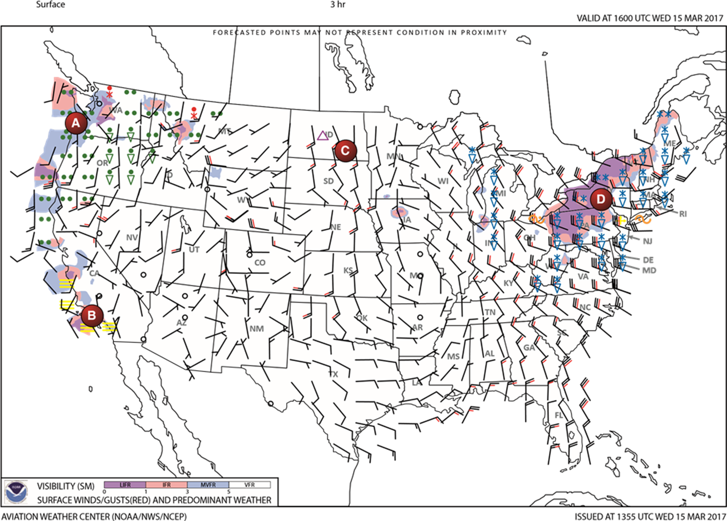
- 3-5 SM
- 1-3 SM
- 0-1 SM
74
(BLM) The reason of the retricted visibility along the coastal waters of Southern California (area B) are forecast to be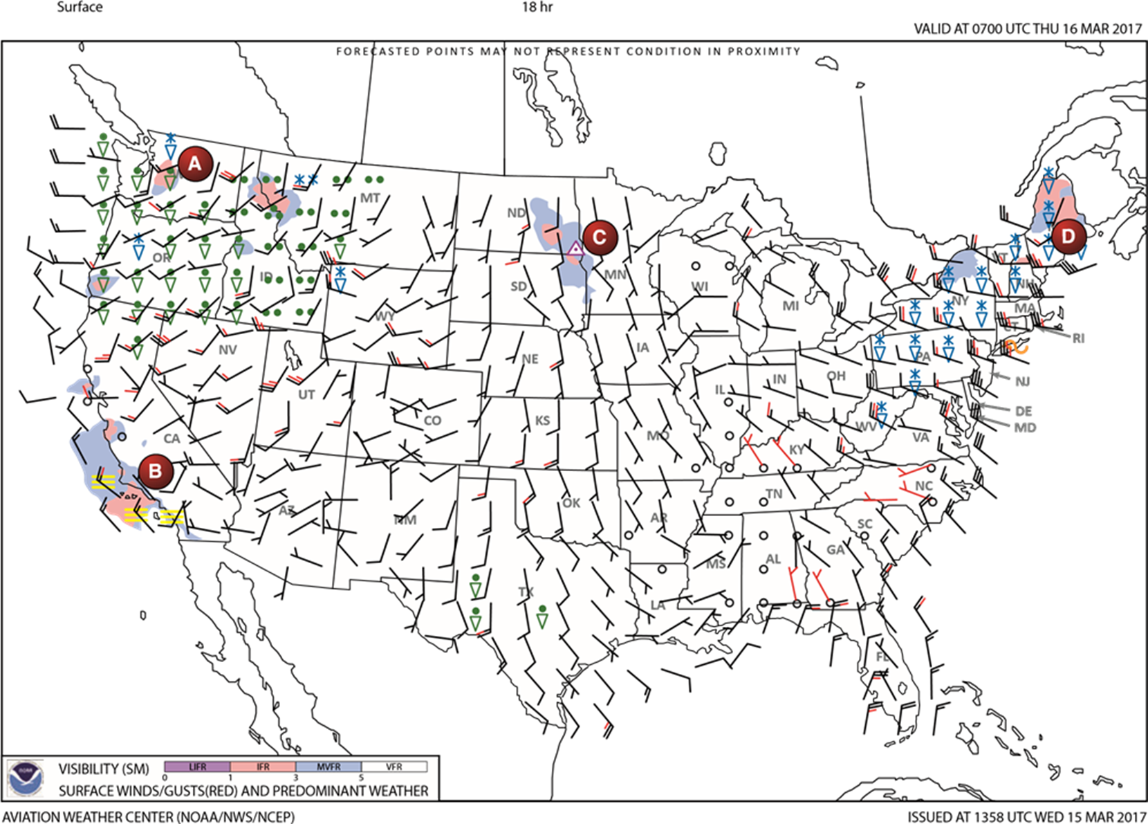
- Fog
- rain showers
- Thunderstorm
75
(BLM) The forecasted surface winds WA(area A) are;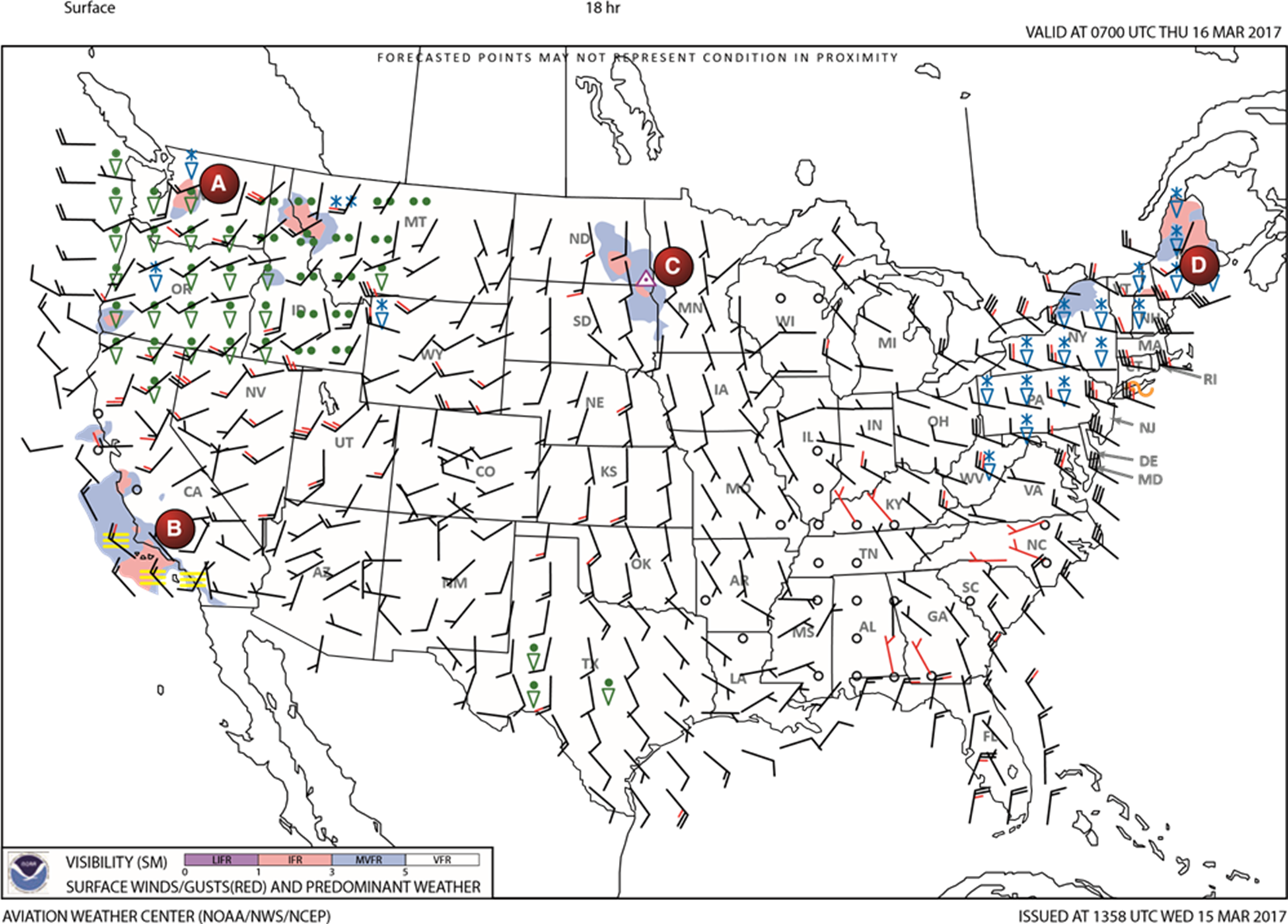
- 10 knots gusting to 30 knots
- 20 knots gusting to 30 knots.
- 15 knots
76
(BLM) The weather forecast in area C (Southern CA) shows;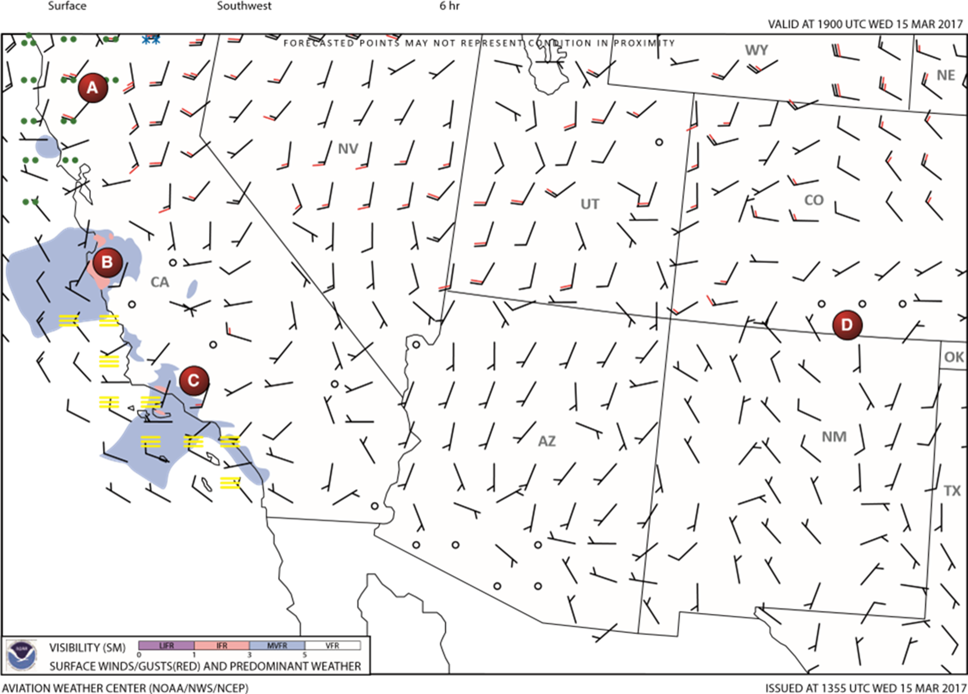
- Low overcast layer 0-1 SM
- Fog and visibility 0-1 SM
- Fog and visibility 3-5 SM
77
What do you have to be careful about when you use Graphical Forecast for Aviation (GFA)?
- Simplified display for non-meteorologist users.
- Available 6 hours in the past up to 15 hours in the future.
- Focused on low-altitude flights common to GA community.
- AIRMET and SIGMET can be turned off unintentionally.
78
(BL) Which is a concise statement of the expected meteorological conditions significant to aviation for a specified time period within 5 nm of the center of the airport's runway complex (terminal).
- Area forecast.
- Terminal aerodrome forecast
- Weather depiction charts
79
(BL) A terminal aerodrome forecast (TAF) covers;
- 5 nautical mile radius of the center of an airport.
- 5 to 10 statute mile radius from the center of an airport runway complex (terminal)
- 5 statute mile radius from the center of an airport runway complex (terminal).
80
(BL) Which weather product should be primarily used for weather information forecasted at your destination at your estimated time of arrival?
- Surface analysis chart.
- Terminal aerodrome forecast.
- METAR
81
Terminal Aerodrome Forecast (TAF) is issued :
- four times per day, at 0000, 0600, 1200, and 1800Z.
- two times per day at 0600, 1800
- three times per day at 0000, 1200
- issued as necessary based.
82
TAF are valid :
- 24 or 30 hours
- 24 hours
- 30 hours
- 12 hours
83
BL pvt. KMEM 131600 "VRB" indicates wind is;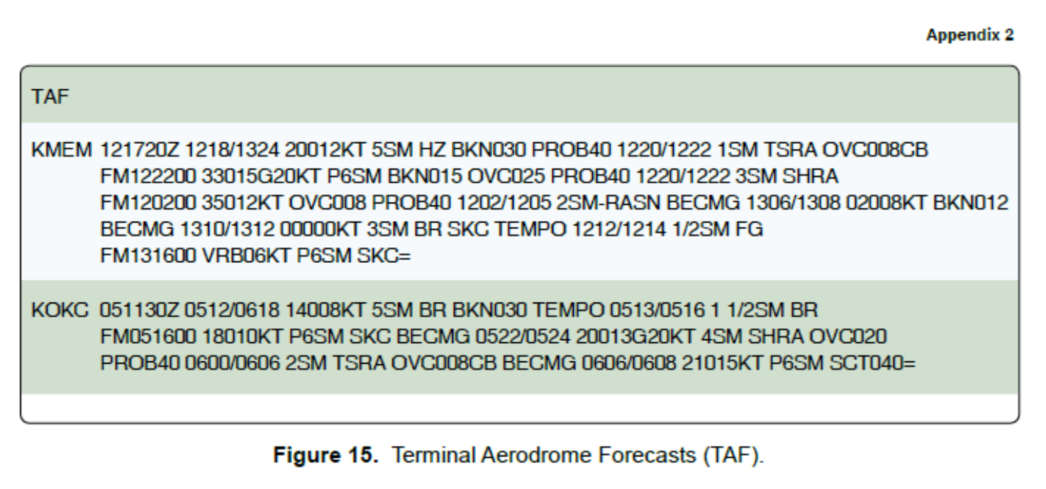
- Cloud Base is variable
- Wind speed variable 1-9 knots.
- Wind direction variable 1-6 Knots
84
KMEM 1310/1312 0000KT means?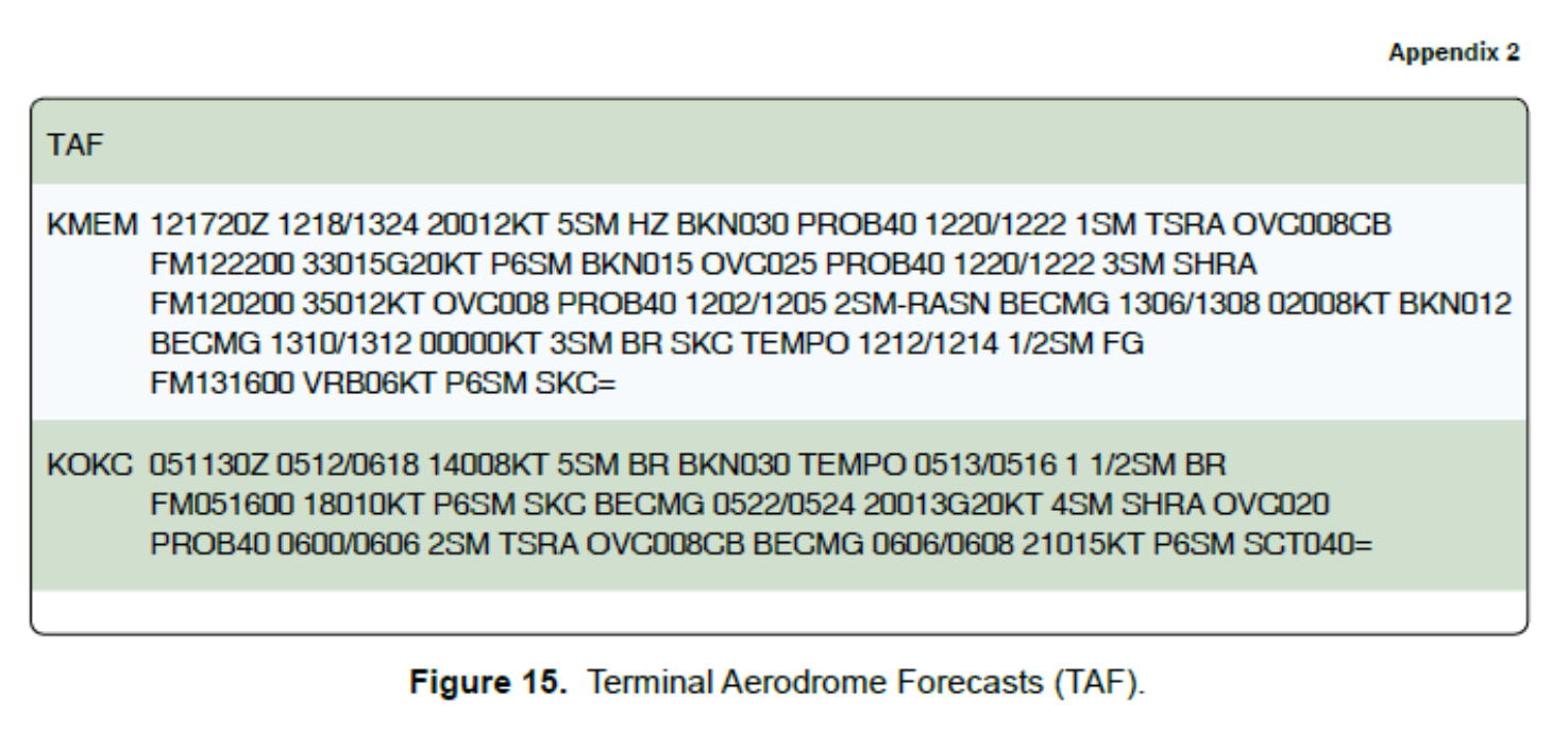
- Wind is not forcasted.
- Wind is Calm.
- Wind is variable
85
What type of weather is forecasted by the term VCTS in the TAF?
- Fogs between 5 and 25 miles of the runway complex
- Rain showers at the distance of 10 miles from the airport
- Thunderstorms are expected in the vicinity