UK’s evolving physical geography: Geography B Edexcel GCSE (P1)
Study these flashcardsFree · spaced repetition · iPhone, Android, Mac & web
All cards
1
igneous rocks
made from magma (eg granite)
2
characteristic of igneous rocks
impermeable, crystals, very hard
3
sedimentary rock
compressed sediment (eg clay chalk limestone)
4
sedimentary rock characteristics
permeable, clear layers
5
metamorphic rock
igneous or sedimentarybchanged by heat or pressure (eg shale into slate)
6
metamorphic rock characteristics
crystals, impermeable, very hard
7
how is the uk split geologically
tees-exe line
-top half mainly igneous metamorphic forming upland kandscapes
-bottom half mainly sedimentary forming lowland landscape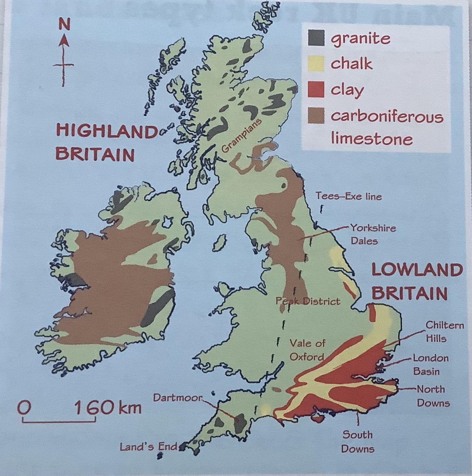
-top half mainly igneous metamorphic forming upland kandscapes
-bottom half mainly sedimentary forming lowland landscape
8
how does glaciation effect uk landscape
top half glaciated during last ice age, ice pressed down on landscape and eroded it in distinctive ways
bottom half not covered in ice sheets but influenced by glacial depostion, clays sand etc eroded by glaciers and deposited in southern areas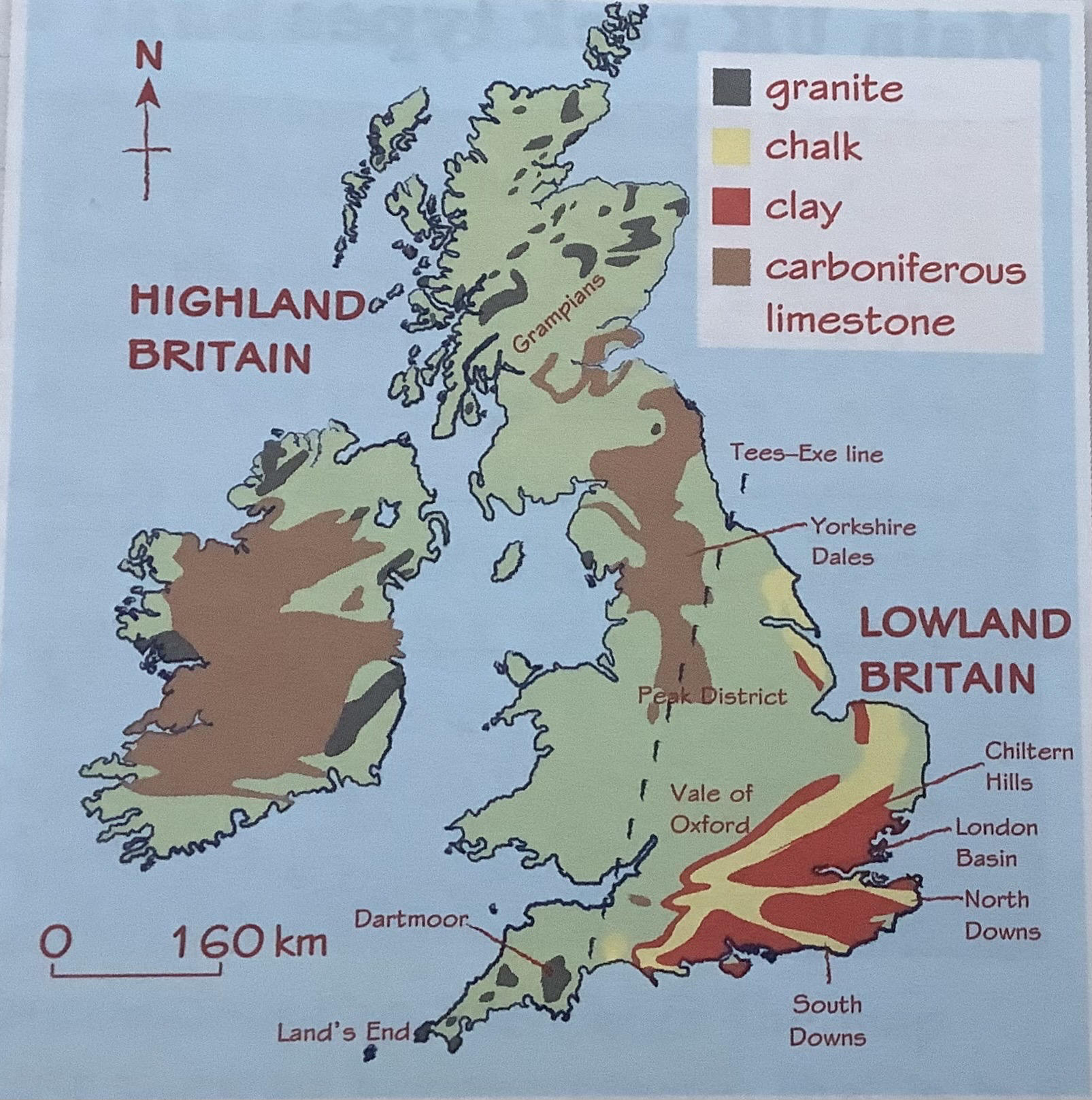
bottom half not covered in ice sheets but influenced by glacial depostion, clays sand etc eroded by glaciers and deposited in southern areas
9
landscape from past tectonic
-mountains
-land creation
-igneous land forms from volcanoes
-land creation
-igneous land forms from volcanoes
10
sedimentary (chalk, carboniferous limestone, clay) landscapes
-chalk strong + permeable (water moves through it) forming cliffs at coastlines
-chalk only lowland britain
-clay weak and impermeable (water cant move through it)
-clay all over britain- wide flat plains with lots of lakes streams and rivers
-water draining through chalk flows out as springs along line where permeable chalk meets impermeable clay
-carboniferous limestone is permeable + chemically weathered by rainwater, landscapes have distinctive features like underground caves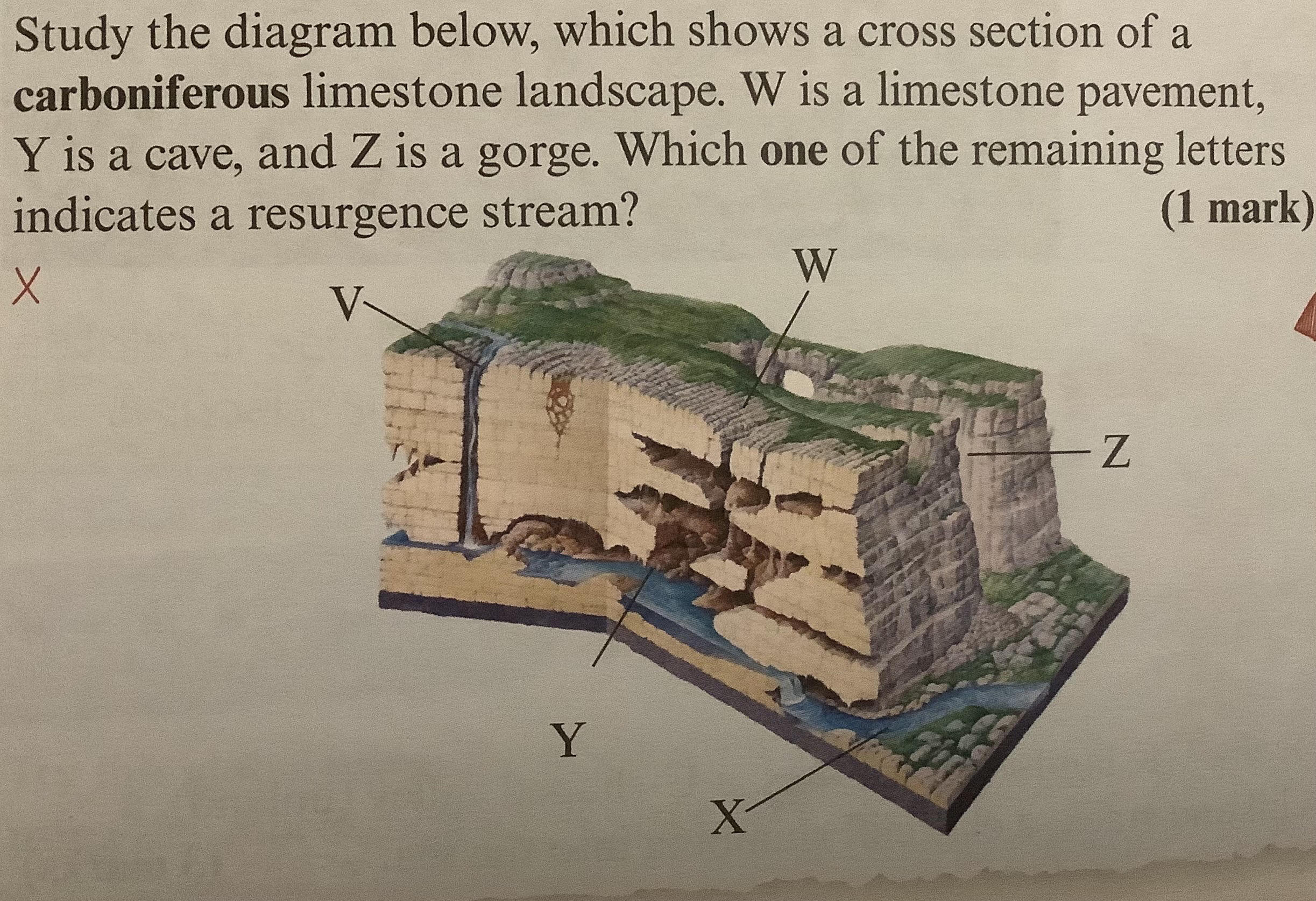
-chalk only lowland britain
-clay weak and impermeable (water cant move through it)
-clay all over britain- wide flat plains with lots of lakes streams and rivers
-water draining through chalk flows out as springs along line where permeable chalk meets impermeable clay
-carboniferous limestone is permeable + chemically weathered by rainwater, landscapes have distinctive features like underground caves
11
igneous (granite)landscapes
-granite hard + resistant to erosion but susceptible to chemical weathering
-granite impermeable so landscapes badly drained (boggy)
-tors (towers of granite chemically weathered into blocks)
-granite impermeable so landscapes badly drained (boggy)
-tors (towers of granite chemically weathered into blocks)
12
metamorphic (schists + slate) landscapes
-strong + very resistant to erosion + weathering
-slate formed from clay, layers in original clay form weak planes in slate
-schists (formed from shale, rocks split easily)
-slate formed from clay, layers in original clay form weak planes in slate
-schists (formed from shale, rocks split easily)
13
upland landscape physical processes
-corrie formed from glacier in ice age (‘post-glacial’)
-rock weathering means rock fragments break off, falling to base of cliff, forming steep slope
-high precipitation means lots of surface drainage over impermeable rocks (lots of streams)
-u-shaped valleys from glaciers (flat bottom + steep sides)
-rock weathering means rock fragments break off, falling to base of cliff, forming steep slope
-high precipitation means lots of surface drainage over impermeable rocks (lots of streams)
-u-shaped valleys from glaciers (flat bottom + steep sides)
14
lowland landscapes physical processes
-river meanders erodes wide valleys between low hills
-river transports silt eroded from river channel
-rivers flood after prolonged heavy rain, spreading over valley floor, depositing silt to form wide flat floodplain
-river transports silt eroded from river channel
-rivers flood after prolonged heavy rain, spreading over valley floor, depositing silt to form wide flat floodplain
15
agriculture landscape (human activity)
-drainage ditches, built to drain water away from low-lying agricultural land, allowing crops to grow
-trees cleared for space
-different farming for different landscapes eg sheep highland + arable farming in fertile lowland valleys
-trees cleared for space
-different farming for different landscapes eg sheep highland + arable farming in fertile lowland valleys
16
forestry landscape (human activity)
planting managing + caring for forests for purposes like natire conservation, landscaping, recreatiom + timber production
-tree planting sometimes in straight rows to make forestey easier to manage
-naturally covered by deciduous woodland, but some landscapes have coniferous which planted for timber and are very distinctive
-trees felled for timber leaves cleared areas
-tree planting sometimes in straight rows to make forestey easier to manage
-naturally covered by deciduous woodland, but some landscapes have coniferous which planted for timber and are very distinctive
-trees felled for timber leaves cleared areas
17
settlement landscape (human activity)
settlements in advantaged landscapes
-river meanders loops make good defense
-natural harbours as sites for fishing villages
-shallow points of rivers as fords (crossing point)
-springs give reliable freshwater
-in big cities many streams + small rivers run im tunnels underground
-river meanders loops make good defense
-natural harbours as sites for fishing villages
-shallow points of rivers as fords (crossing point)
-springs give reliable freshwater
-in big cities many streams + small rivers run im tunnels underground
18
soft rock’s (rock type) influence on erosional coastal landforms
-easily eroded by sea
-cliffs less rugged + less steep than harder rock coasts
-include bays
-cliffs less rugged + less steep than harder rock coasts
-include bays
19
joints + faults (geological structure) influence on erosional landforms
joints= smaller cracks in rock, faults= larger cracks in rock
-both make rock susceptible to erosion
-rocks with more erode quicker
-both make rock susceptible to erosion
-rocks with more erode quicker
20
hard rock (rock type) influence on erosional coastal landforms
-resistant to erosion
-cliffs high, steep, rugged
include wave-cut platforms + headlands where caves, arches, stacks form
-cliffs high, steep, rugged
include wave-cut platforms + headlands where caves, arches, stacks form
21
concordant + discordant coasts (geological structure) influence on erosional landforms
concordant= made up of smae rock type, parallel to sea
discordant= rock type alternates in layers perpendicular to sea, forming headlands + bays
-concordant more even erosion
-discordant alternating erosion (headlands + bays)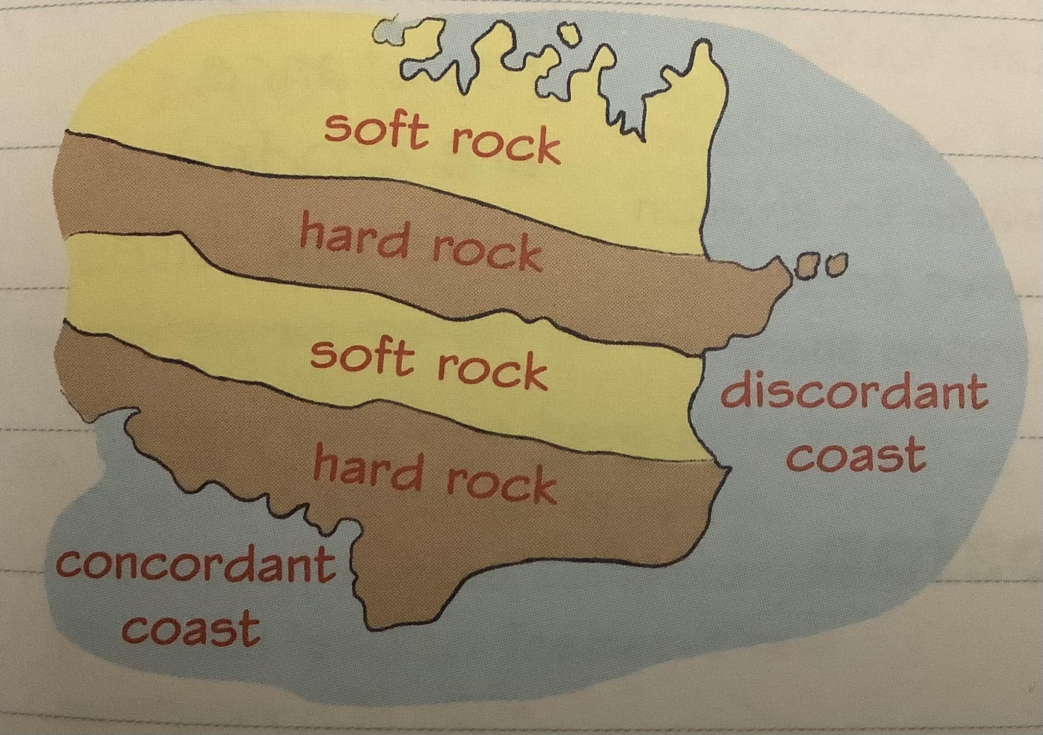
discordant= rock type alternates in layers perpendicular to sea, forming headlands + bays
-concordant more even erosion
-discordant alternating erosion (headlands + bays)
22
other factors affecting rates of erosion on coasts
-wave climate (wave power, directiom, height, fetch etc)
-local currents + tidal range
-growndwater levels (saturated cliffs (highground water) more vulnerable)
-geological structure eg soft + hard rock occur together
-local currents + tidal range
-growndwater levels (saturated cliffs (highground water) more vulnerable)
-geological structure eg soft + hard rock occur together
23
formation of headlands + bays
caused by differential rates of erosion 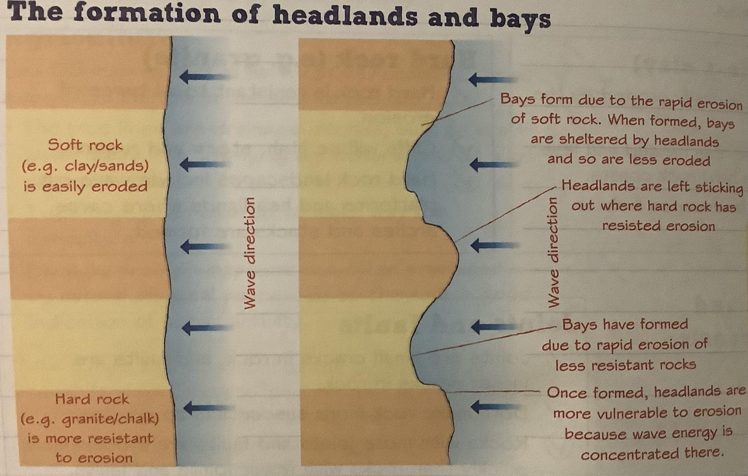
24
formation of wave-cut platforms
area of flat rock at base of cliff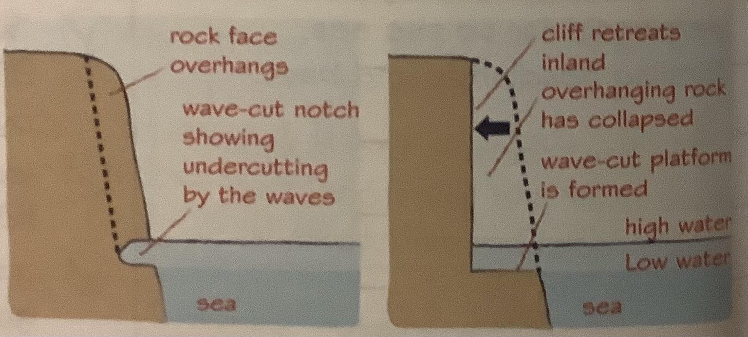
25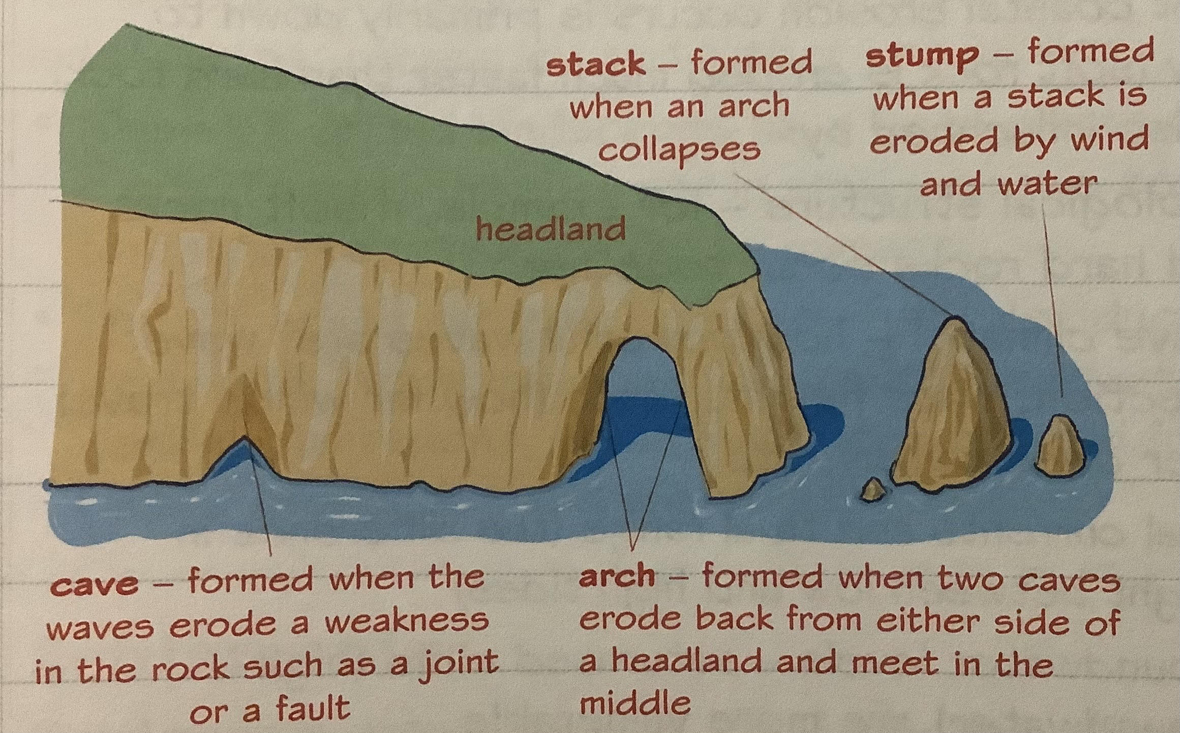
formation of caves, arches + stacks
26
hydraulic action (coast)
-force of water against coastline/ river bank + bed causes erosion
-water compress air in cracks in rocks, forcing them apart + weakening rock
-water compress air in cracks in rocks, forcing them apart + weakening rock
27
abrasion
breaking waves throw sand + pebbles (or boulders) against river bed/ coast during storms
28
attrition
rocks + pebble carried by waves rub together + break down into smaller pieces
29
solution
chemical action by (sea)water on some rocks especially limestone
30
destructive waves
swash= weak, backwash= strong so material is dragged back down a beach to sea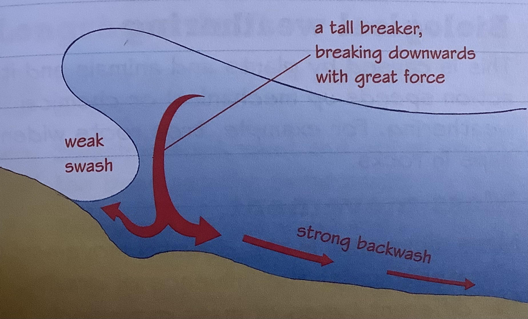
31
seasonality (impact of uk climate on coastal erosion)
-different seasons have different impact on coastal erosion
-eg cold temp in winter lead to freeze thaw weathering in cliffs
-eg cold temp in winter lead to freeze thaw weathering in cliffs
32
storm frequency (impact of uk climate on coastal erosion)
-high storm frequency in many parts of uk
->so coasts often subject to strong winds, leading to increase in eroding power of waves
->so heavy rainfall contribute to mass movement
->so coasts often subject to strong winds, leading to increase in eroding power of waves
->so heavy rainfall contribute to mass movement
33
prevailing winds (impact of uk climate on coastal erosion)
-from south-west
-bring warm, moist air from atlantic + frequent rainfall, meaning weathering and mas movement on coast
-bring warm, moist air from atlantic + frequent rainfall, meaning weathering and mas movement on coast
34
mechanical weathering (coast)
freeze-thaw= water freezes in cracks when cold + rock expands, over time crack widens and pieces fall off (most effective when weather frequently rises above and falls below 0*c
35
biological weathering (coast)
caused by plants + animals and its action speeds up mecahnical or chemical weathering (eg tree roots widen gaps in rocks)
36
chemical weathering (coast)
rock’s mineral composition changes
-granite has feldspar which converts to soft clay minerals a reuslt of chemical reaction w/ water
-limestone dissolved by carbonation (co2 in atmosphere combines w/ rainwater forming carbonic acid which changes calcium carbonate (limestone) to calcium bicarbonate, then carried away by water (solution))
-granite has feldspar which converts to soft clay minerals a reuslt of chemical reaction w/ water
-limestone dissolved by carbonation (co2 in atmosphere combines w/ rainwater forming carbonic acid which changes calcium carbonate (limestone) to calcium bicarbonate, then carried away by water (solution))
37
mass movement (coast)
-downhill movement of material under influence of gravity
-types of mass movement depend on material involved, amount of water in material + nature of movement (eg falls, slips, rotational slides)
-types of mass movement depend on material involved, amount of water in material + nature of movement (eg falls, slips, rotational slides)
38
coastal retreat
coastline moves further inland due to coastal erosion
39
slumps (mass movement) (coast)
rock (often clay) saturated with water + slides down curved slip plane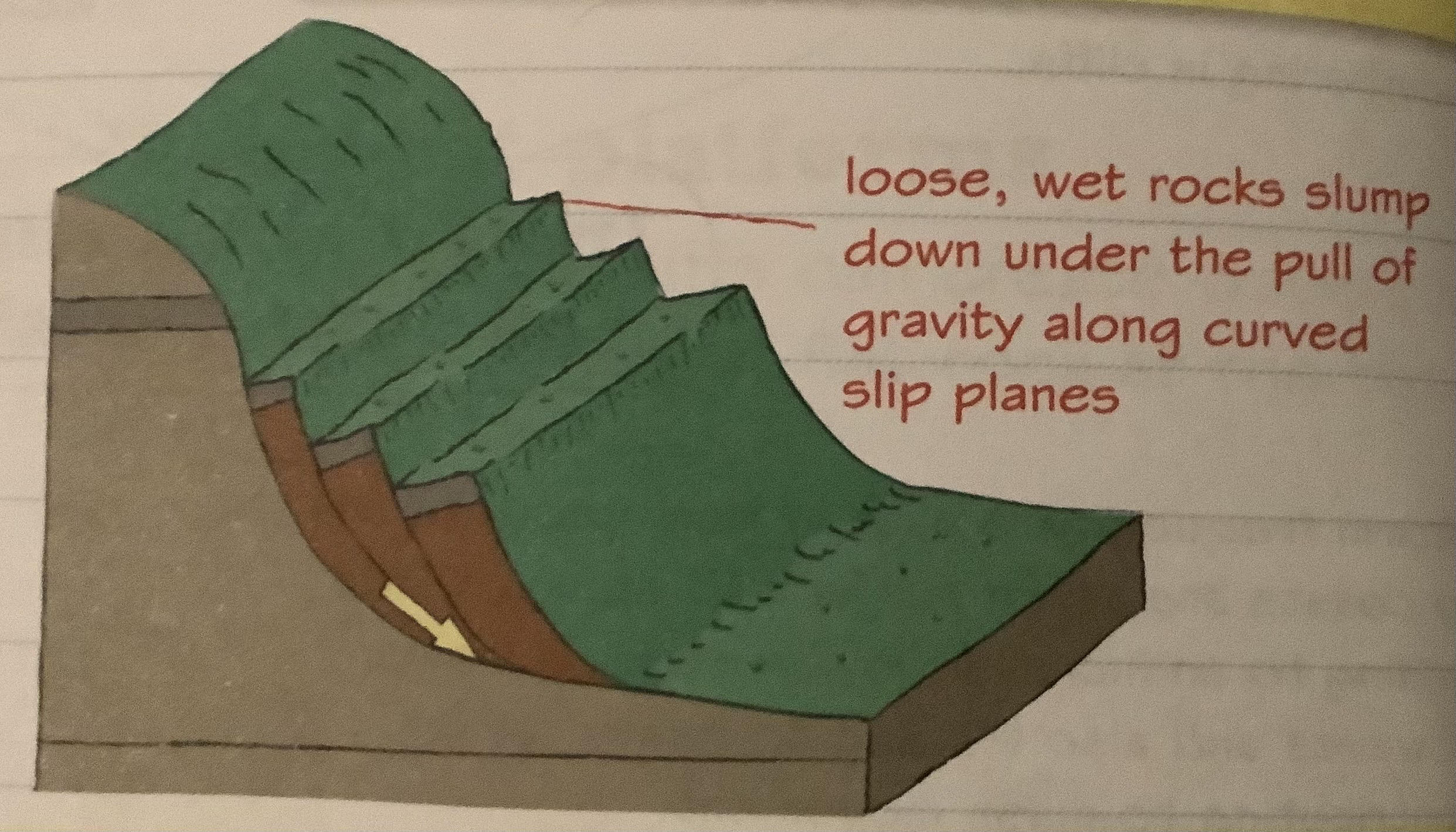
40
sliding (mass movement)
loosened rocks + soil tumble down slope (blocks of material might all slide together) 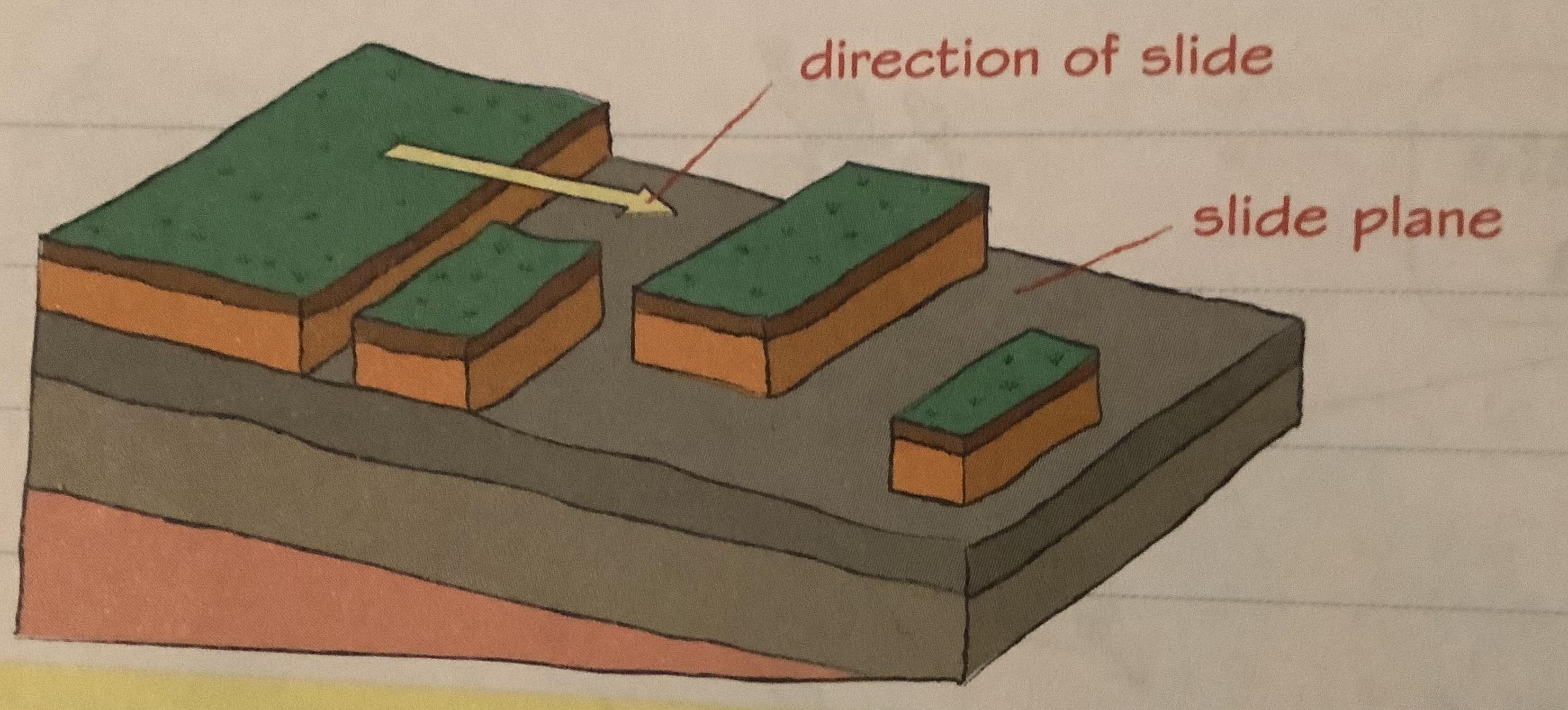
41
longshore drift
1. waves approach coast at angle
2. swash pushes sand + gravel up beach at same angle
3. backwash carries it back perpendicular to coastline (gravity)
4. sand + gravel move along beach in zigzag
5. sand is lighter so moves further up beach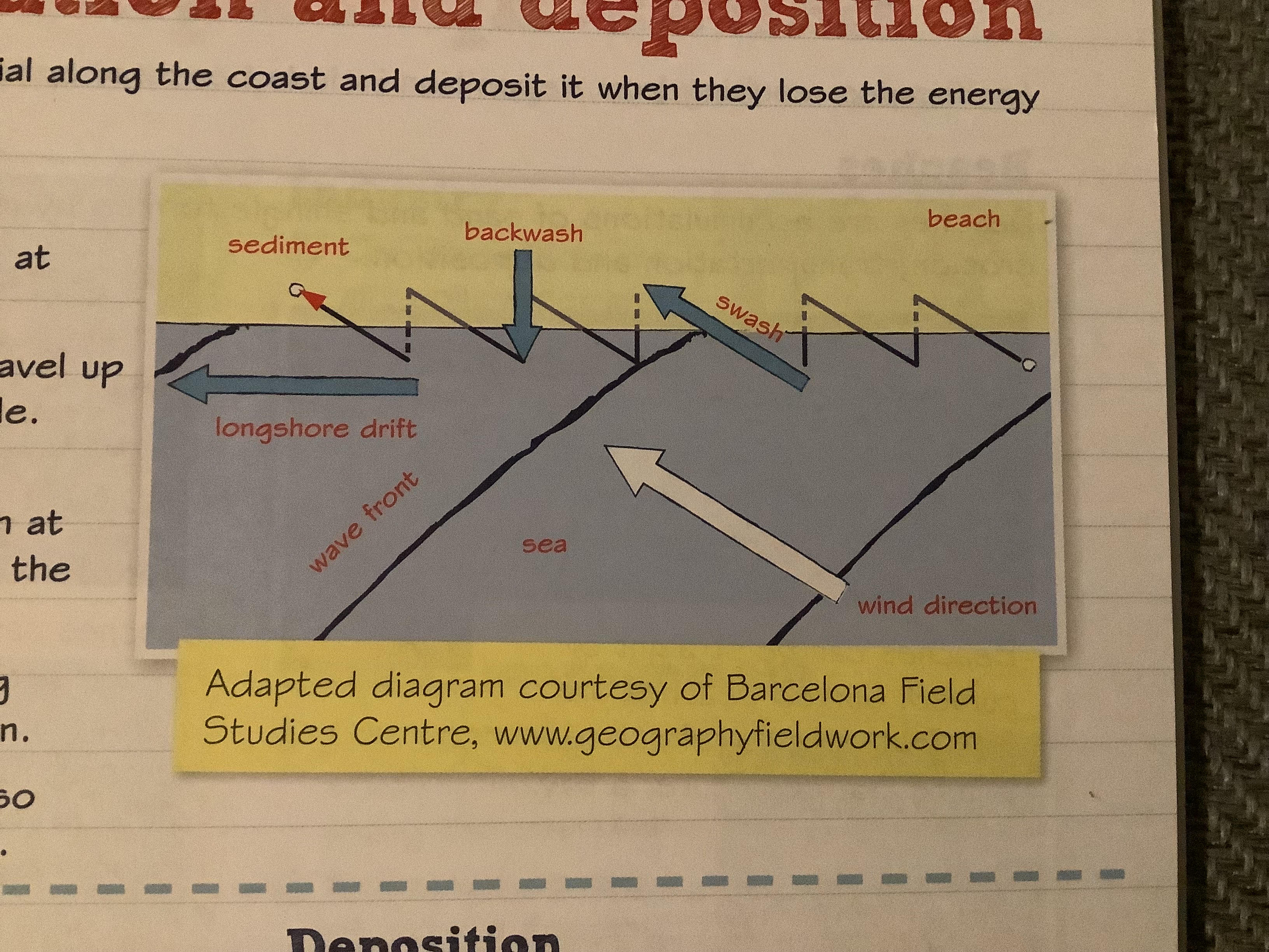
2. swash pushes sand + gravel up beach at same angle
3. backwash carries it back perpendicular to coastline (gravity)
4. sand + gravel move along beach in zigzag
5. sand is lighter so moves further up beach
42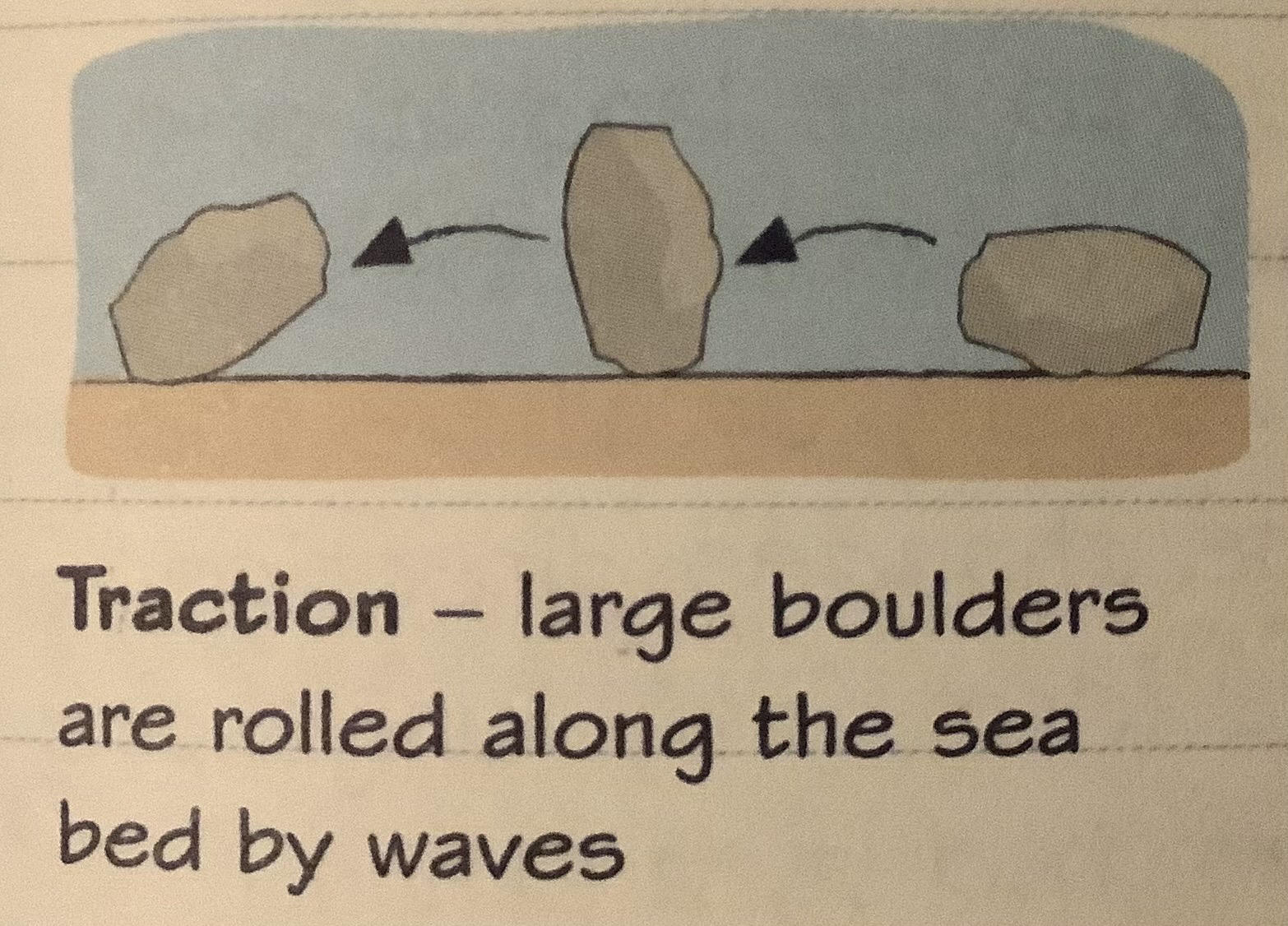
traction (transportation)
43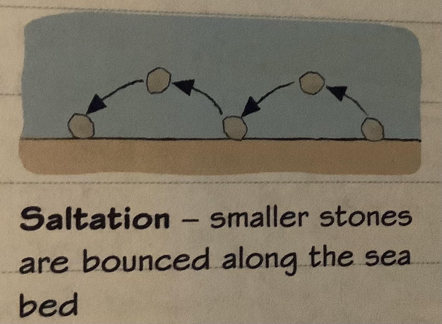
saltation (transportation
44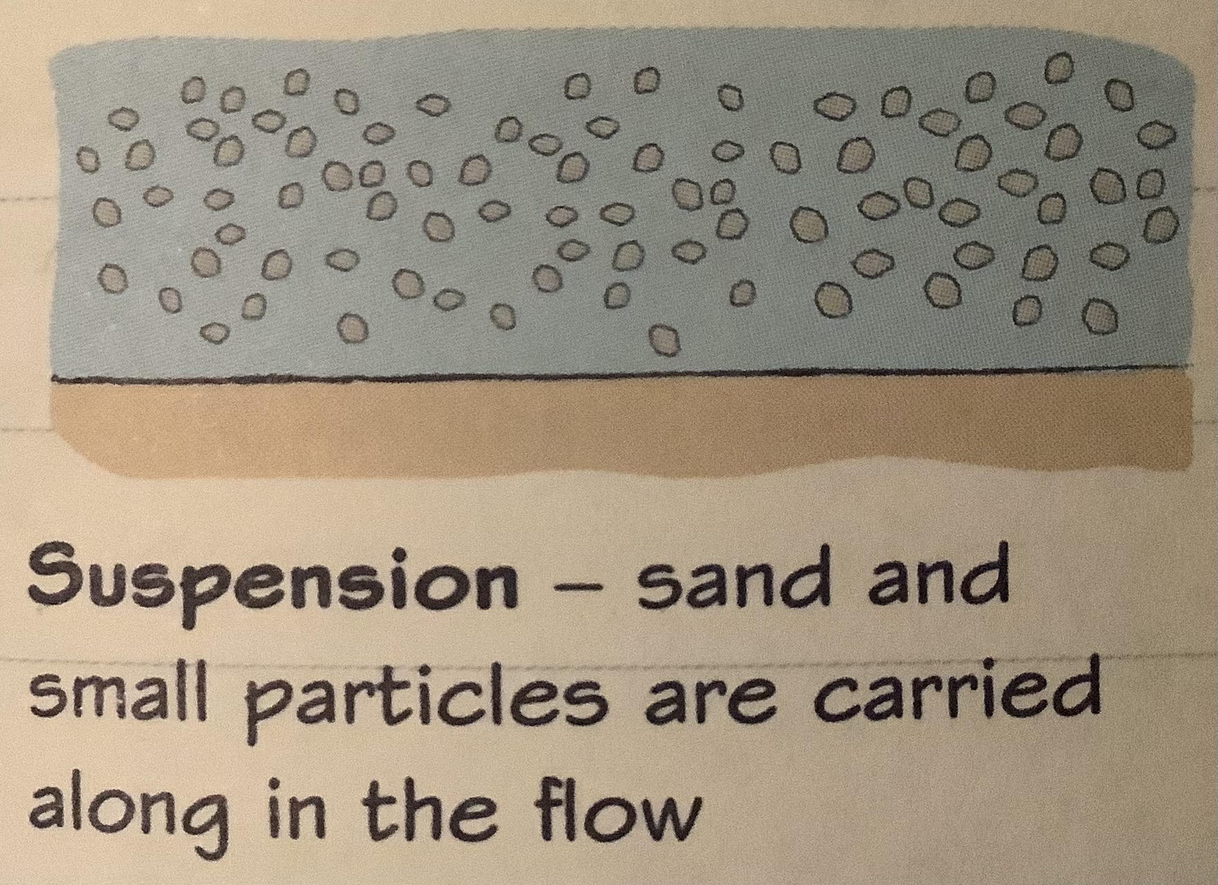
suspension (transportation)
45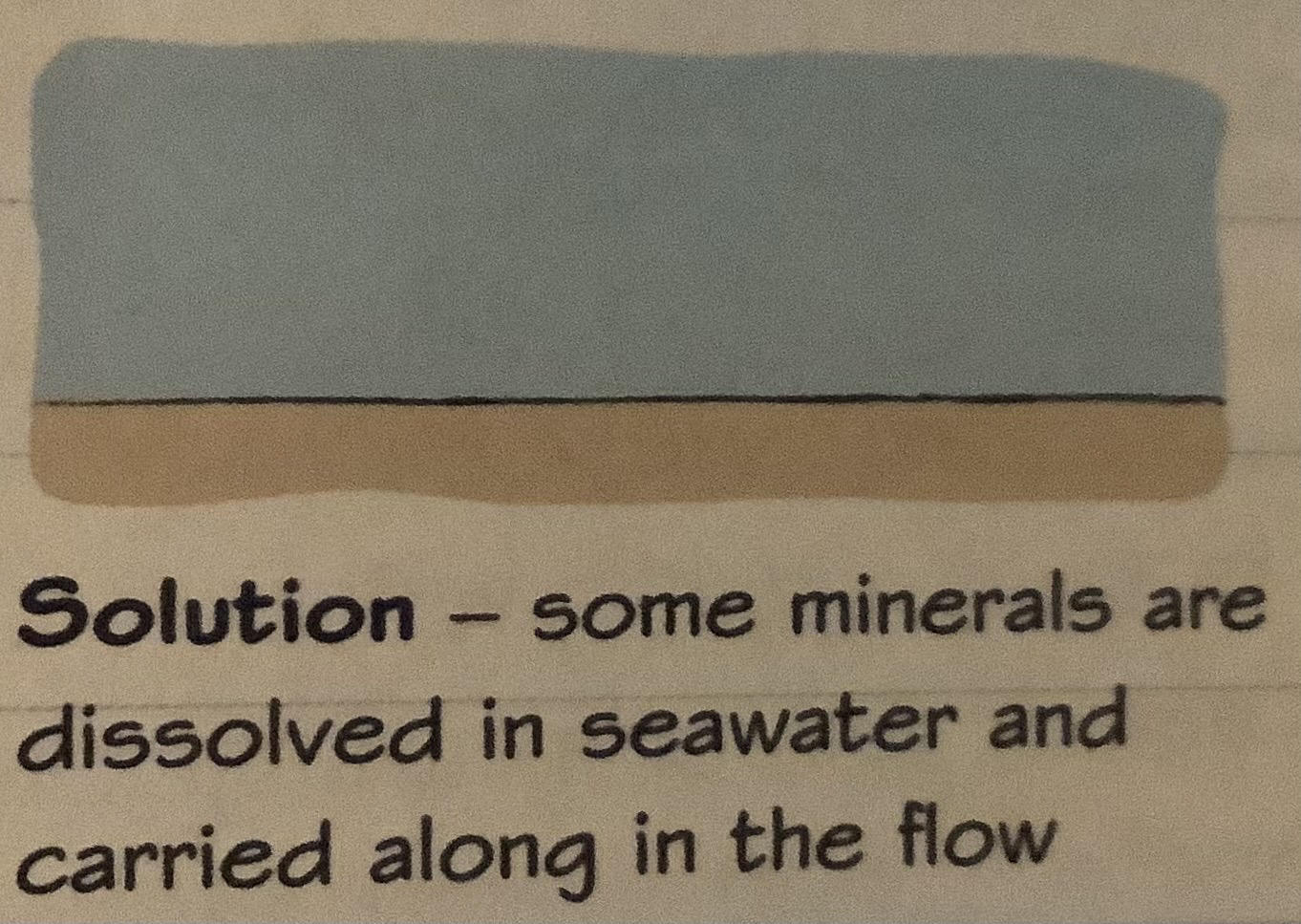
solution (transportation)
46
constructive wave
-load carried by waves deposited by constructive waves
-sheltered spots eg bays, calm conditions, gentle gradient offshore causimg friction all reduce wave energy, influencing deposition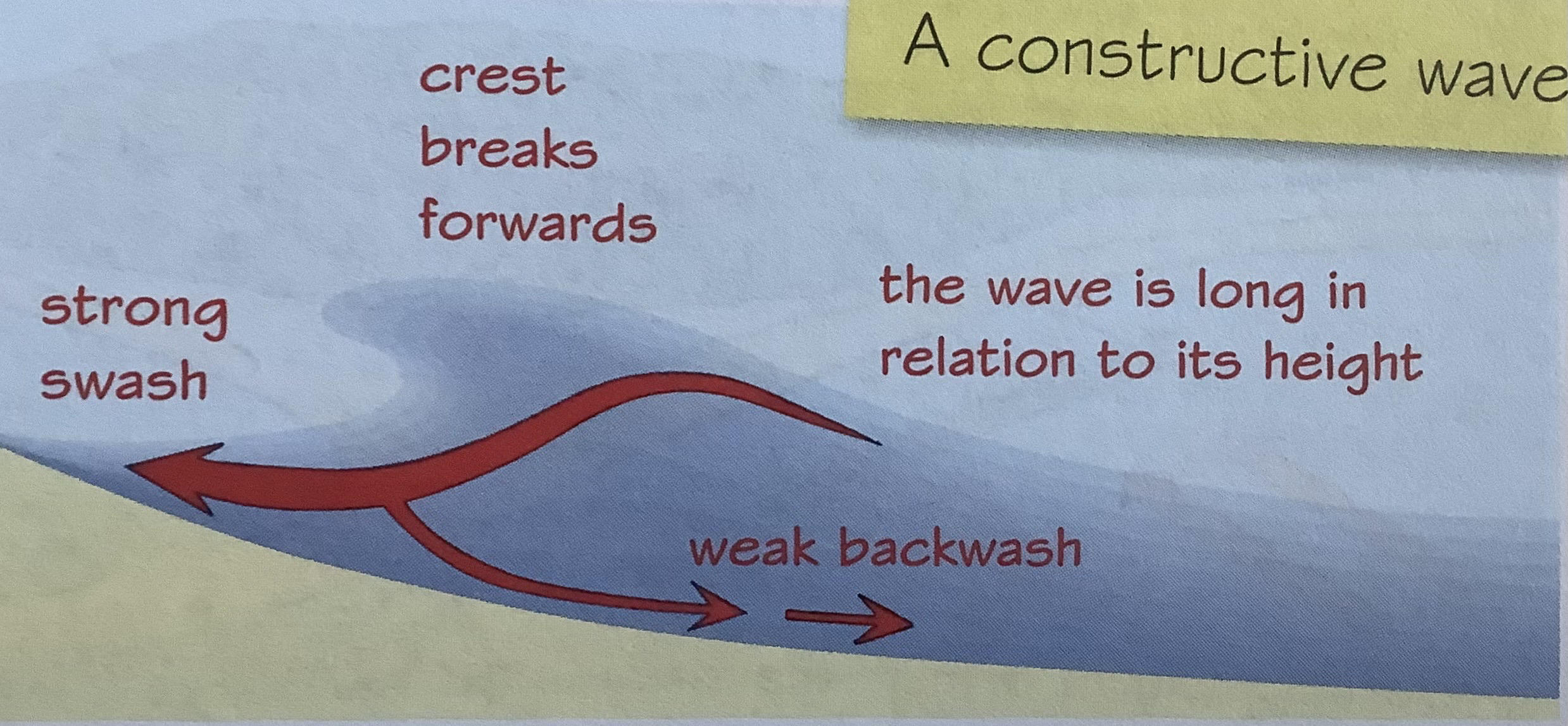
-sheltered spots eg bays, calm conditions, gentle gradient offshore causimg friction all reduce wave energy, influencing deposition
47
Spits (landscape of deposition)
narrow projections of sand/ shingle attached to land at one end, extend across bay/ estuary where coastline changes direction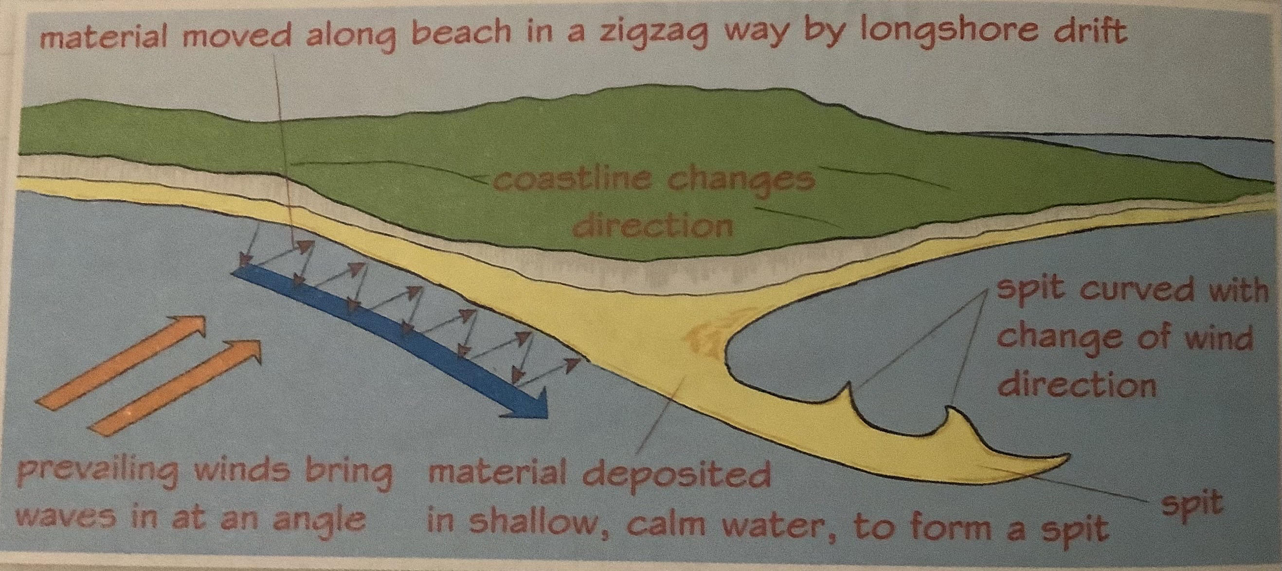
48
bars
form same way as spits but bars grow across bay cutting off water to form lagoon
49
types of beaches
-curved (refracting or bending as they enter bay) or straight
-snady or pebbly/ shingle (shingle usually where cliffs are eroded + where waves powerful
-snady or pebbly/ shingle (shingle usually where cliffs are eroded + where waves powerful
50
berms
ridges in beach parallel to sea (highest up beach shows highest tide)
51
Developement pros + cons (human impact on coast)
-weight of buildings increase cliff vulnerability
-changes in drainage increase saturation
+raises interest in protecting coastal landscape
-changes in drainage increase saturation
+raises interest in protecting coastal landscape
52
industry pros + cons(human impact on coasts)
-cause/increase air, soil, water + noise pollution
-destroy natural habitatsfor birds, animals + sea life
+bring wealth + jobs to area
-destroy natural habitatsfor birds, animals + sea life
+bring wealth + jobs to area
53
agriculture pros+ cons(human impact on coast)
-increased soil erosion
-increase sedimentation
+wildlife habitats created and preserved
-increase sedimentation
+wildlife habitats created and preserved
54
coastal management pros + cons(human impact on coast)
-increase erosion further along coastline
+reduce risk of coastal flooding
+salt marshes, sand dunes, sand bars, spits preserved + protected
+reduce risk of coastal flooding
+salt marshes, sand dunes, sand bars, spits preserved + protected
55
Holderness coast case study- location significance
-soft clay, easily eroded + prone to slumping when saturated
-exposed to strong waves from north sea
-harder chalk rock at flamborough head
-farmland, property + settlements lost to sea changing landscape permanently
-exposed to strong waves from north sea
-harder chalk rock at flamborough head
-farmland, property + settlements lost to sea changing landscape permanently
56
Holderness coast case study- physical processes at work
-coastal erosion (strong waves especially in storms + rock type ensure rapid coast erosion)
-mean rate of erosion ~2m/year (fastest eroding coastline in europe)
-mass movement (clay slumps from cliffs after rainfall)
-transportation (strong waves move eroded material away from coastline)
-mean rate of erosion ~2m/year (fastest eroding coastline in europe)
-mass movement (clay slumps from cliffs after rainfall)
-transportation (strong waves move eroded material away from coastline)
57
Holderness coast case study- human processes at work
-hard engineering (eg groynes + rock armour at mappleton protected some areas from erosion + cliff collapse)
-hard engineering in some places prevents transportation, making erosion worse other places (no beaches created to take full force of waves)
-hard engineering in some places prevents transportation, making erosion worse other places (no beaches created to take full force of waves)
58
increase risk of coastal flooding due to climate change
-atmospheric temp rise so storm freq + strength increase, increase height + strength of waves reaching coast (especially w/ high tides), inc rainfall + wind also inc weathering + mass movement
-sea temp inc so water expands + sea lvl rise, melting ice on land also rises sea lvl, put low-lying coastal land at inc risk flood
-sea temp inc so water expands + sea lvl rise, melting ice on land also rises sea lvl, put low-lying coastal land at inc risk flood
59
effects of climate change on coastal environment
-erosion inc (some beaches disappear)
-depositionsl features eg spit submerged/ destroyed
-natural ecosystems + habitats destroyed
-erosion inc (more coastal retreat + cliff collapse)
-depositionsl features eg spit submerged/ destroyed
-natural ecosystems + habitats destroyed
-erosion inc (more coastal retreat + cliff collapse)
60
impacts of inc risk of flooding on ppl
-storm surges (ingury/death)
-psychological impacts on losing homes + livelihood
-settlements moves/ defended (expensive)
-dec coastal tourism if beaches/ landscapes lost
-flooded roads + railway make travel difficult
-loss of agricultural land affect food production + economy
-psychological impacts on losing homes + livelihood
-settlements moves/ defended (expensive)
-dec coastal tourism if beaches/ landscapes lost
-flooded roads + railway make travel difficult
-loss of agricultural land affect food production + economy
61
hard engineering coastal management
sea wall: +protects cliffs + buildings, -expensive
groynes: +prevents sea removing sand, -exposes other coastline areas
groynes: +prevents sea removing sand, -exposes other coastline areas
62
soft engineering coastal management
beach replenishment: +sand reduce wave energy + maintains tourism, -expensive
slope stabilisation: +reduces slippage, -foot of cliff still needs protection
slope stabilisation: +reduces slippage, -foot of cliff still needs protection
63
Integrated Coastal Zone Management
do nothing: +cheaper, -homes + land lost
strategic realignment: +ppl + activities move inland, -unpopular w/ local residents
strategic realignment: +ppl + activities move inland, -unpopular w/ local residents
64
deposition
when water loses energy it may drop some of its load
65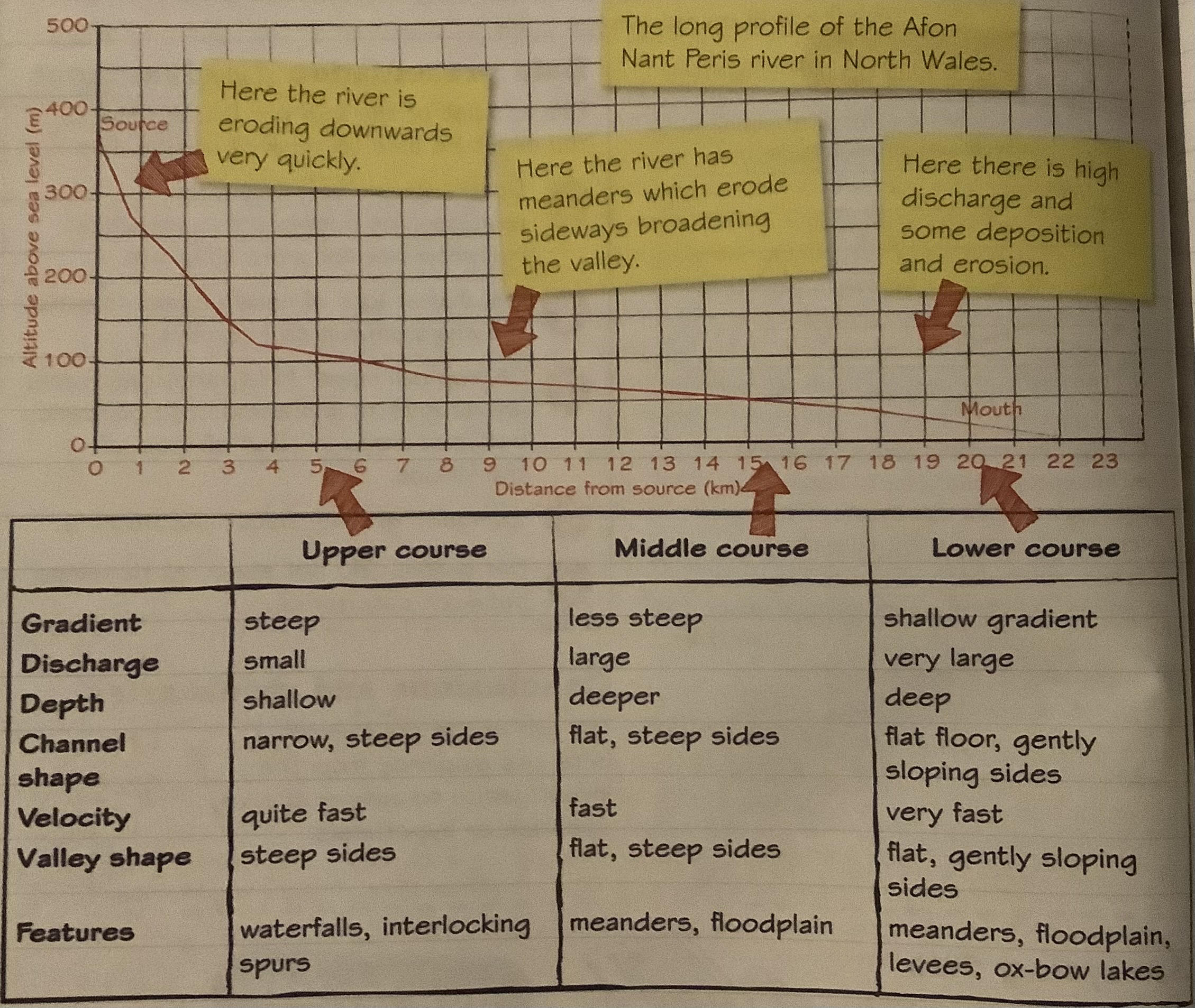
How river landscapes contrast between the upper courses, mid-courses and lower courses of rivers (named example)
66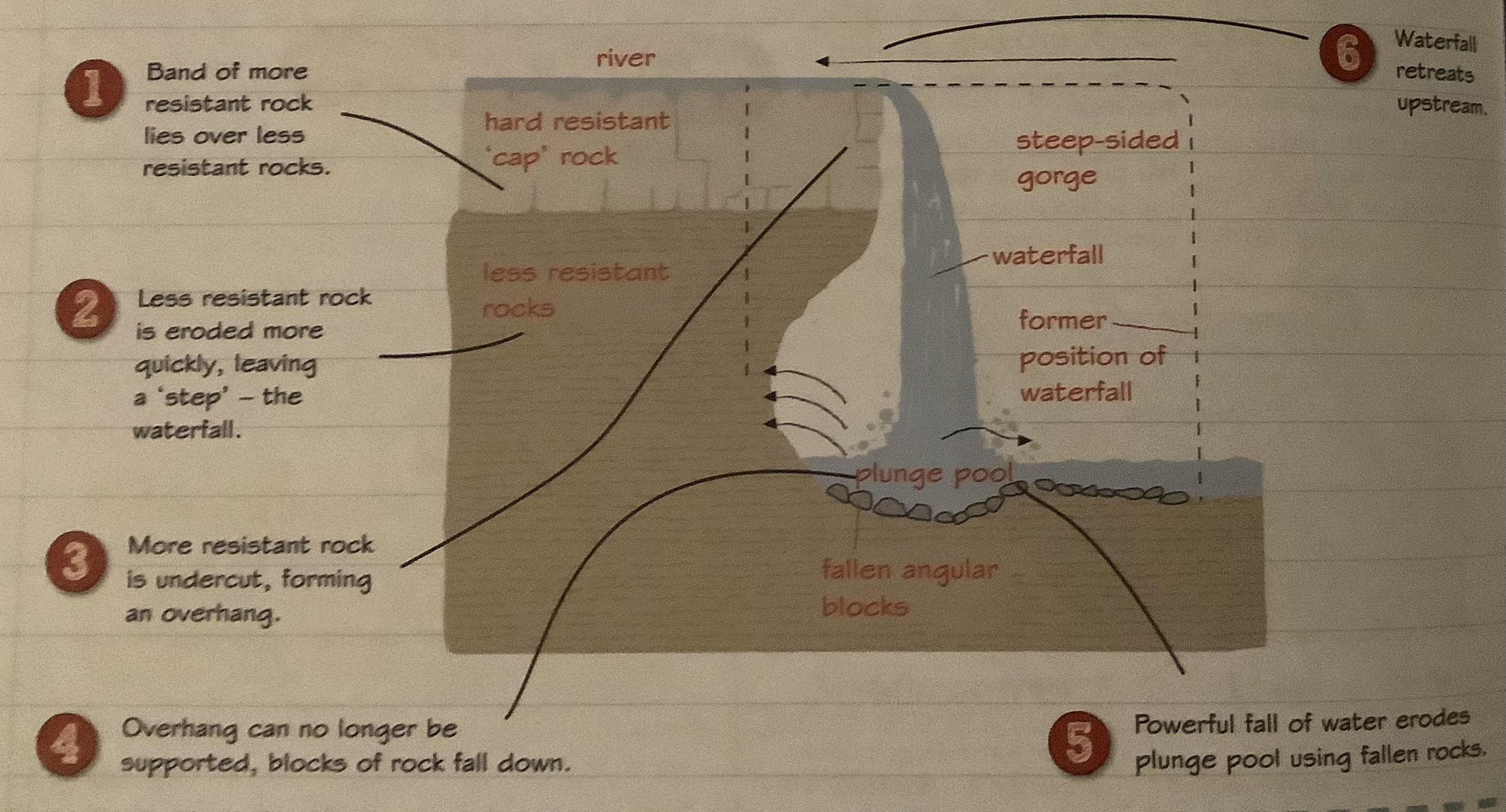
how waterfalls are formed (upper)
67
how are interlocking spurs formed (upper)
at source river is small + has limited energy so flows naturally side to side around ridges in valley sides (spurs), become interlocking
68
meanders (lower)
in lower course river uses up surplus energy by swinging one way and the other, causing erosion (outside) + deposition (inside) 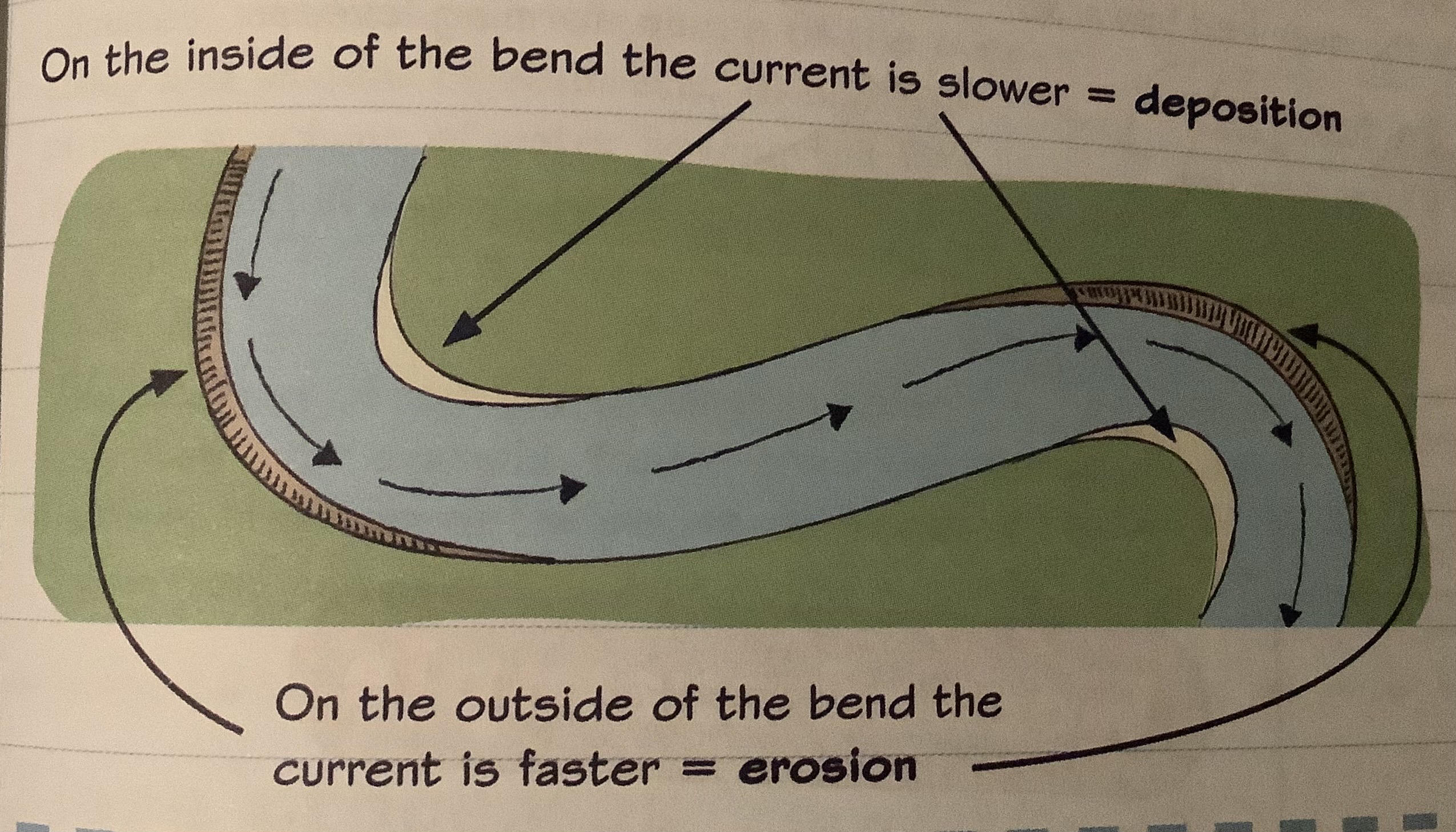
69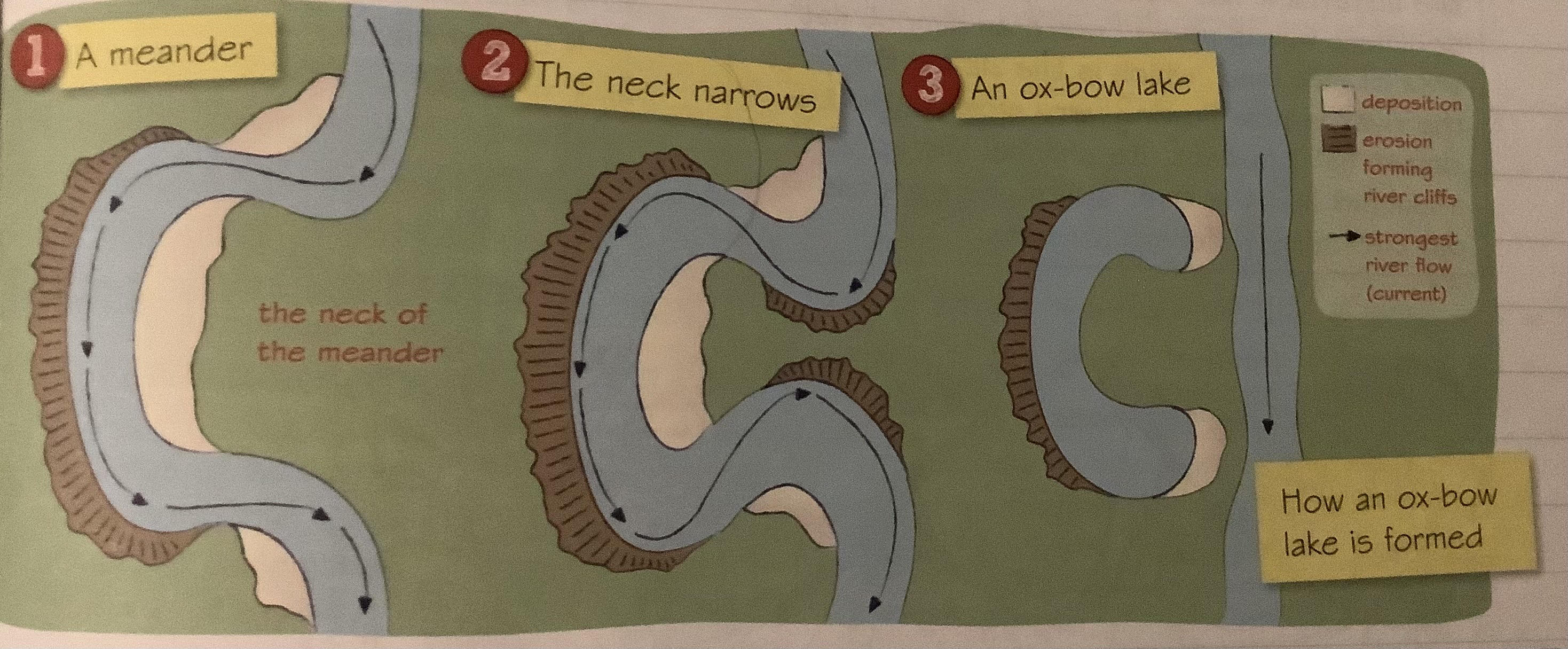
how are oxbow lakes formed (lower)
70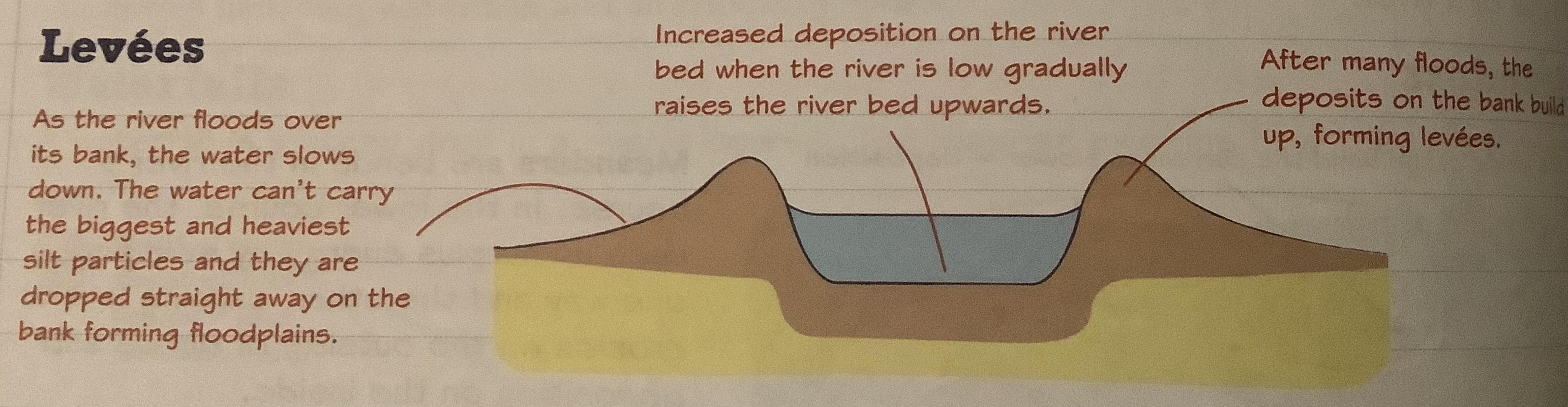
how are levees formed (lower)
71
how are deltas formed (lower)
-speed of river decrease as approach sea + deposits material
-sediment builds up over time creating new land (delta)
-channel splits up into different stream with more bits of land
-sediment builds up over time creating new land (delta)
-channel splits up into different stream with more bits of land
72
soil creep
particles of soil slowly move down sides of valleys (gravity)
-> changes shape of river valley and increase sediment load
-> changes shape of river valley and increase sediment load
73
slumping (rivers)
valley sides eroded by river making sides steeper + increasing downward movement (heavy rainfall triggers this)
-> changes shape of river valley and increase sediment load
-> changes shape of river valley and increase sediment load
74
another name for slope processes
mass movement
75
impact of climate on river landscapes + sediment load
-transportation rate (greater when water energy >, wet country rivers transport more material)
-amount of discharge (wetter= greater discharge, hotter= greater evaporation so less discharge, greter discharge= higher transportation rate)
-weathering (greater in some climates eg freeze-thaw weathering in areas up and down freezing point)
-erosion rate (> when discharge + energy of river >, wetter= more erosion)
-amount of discharge (wetter= greater discharge, hotter= greater evaporation so less discharge, greter discharge= higher transportation rate)
-weathering (greater in some climates eg freeze-thaw weathering in areas up and down freezing point)
-erosion rate (> when discharge + energy of river >, wetter= more erosion)
76
discharge of river meaning
volume of water flowing through river channel at any given time
77
influence of geology on river landscapes + sediment load
-softer rock eg clay more easily erode banks + bed, meaning greater sediment load
-where mix of rock types river carve through soft first (causing interlocking spurs + waterfalls)
-where mix of rock types river carve through soft first (causing interlocking spurs + waterfalls)
78
physical factors explaining storm hydrographs + lag-times
-geology (more resistant rock absorb less watter so run-off greater + faster)
-soil type (impermeable eg clay absorb less so greater + faster run-off, amount of soil also has impact)
-vegetation (plants use water so less + slower run-off w/ them)
-slope (steeper= faster run-off so water reach river quicker)
-drainage basin shape (wide basin w/ lots of close tributaries means water enter river quicker so rising limb steeper + lag time shorter)
-antecedent comditions (ground already saturated means rain flows as run-off to river)
-soil type (impermeable eg clay absorb less so greater + faster run-off, amount of soil also has impact)
-vegetation (plants use water so less + slower run-off w/ them)
-slope (steeper= faster run-off so water reach river quicker)
-drainage basin shape (wide basin w/ lots of close tributaries means water enter river quicker so rising limb steeper + lag time shorter)
-antecedent comditions (ground already saturated means rain flows as run-off to river)
79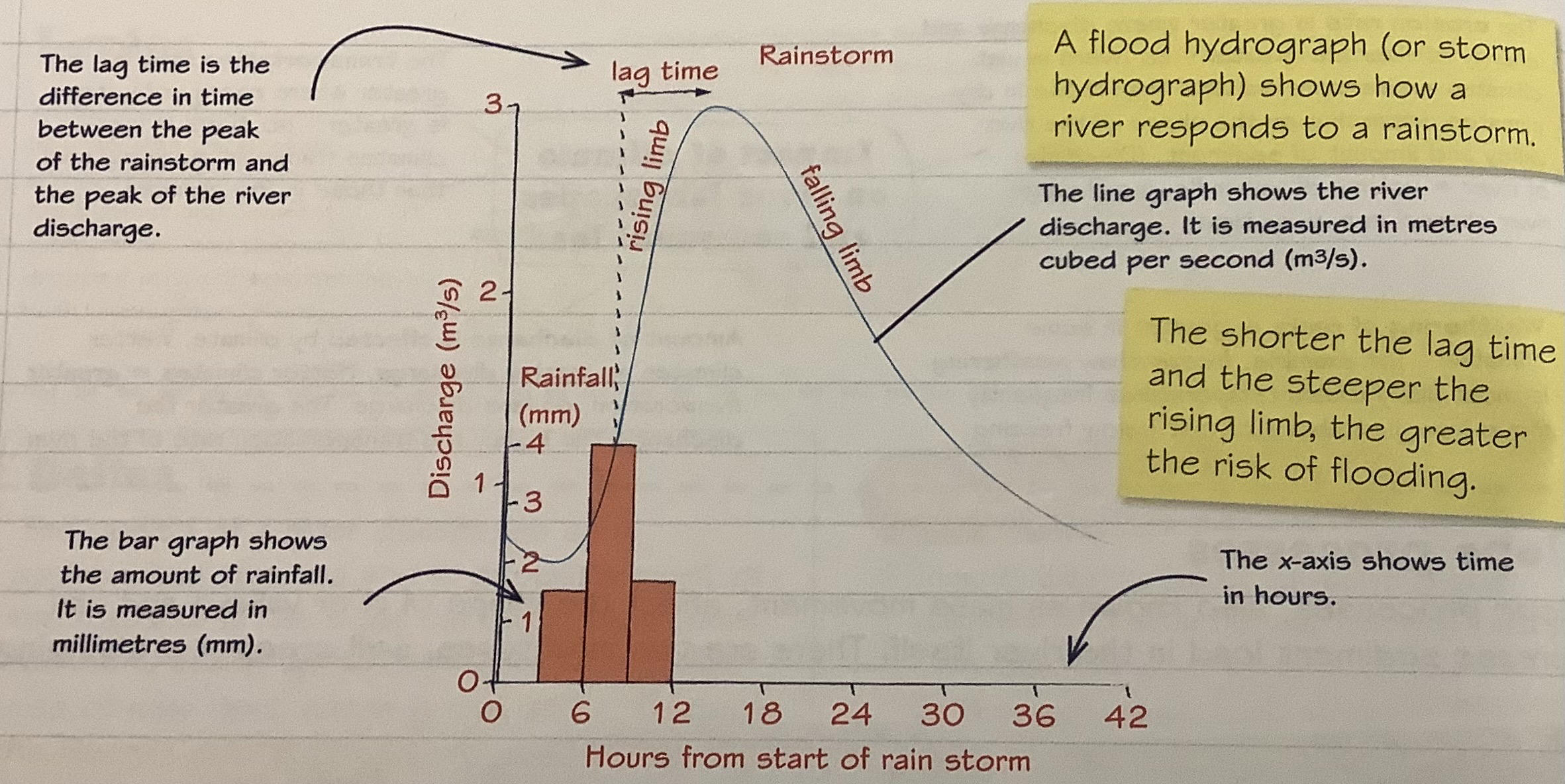
describe hydrograph
80
human activities changing river landscapes + alter storm hydrographs/ increase flooding
-urbanistaion (more impermeable surfaces so more run off)
-deforestation (plants dont absorb water so go to river)
-land-use change
-deforestation (plants dont absorb water so go to river)
-land-use change
81
physical causes of flooding in Tewkesbury (River Severn) + significance of location
-snowmelt across large drainage basin + many tributaries
-heavy rainfall (west of uk) (increase severity due to climate change)
-2 of largest uk rivers (severn + avon) meet there
-before reaching tewkesbury travels through mountains (steep slopes = more surface run off) (more rain)
-heavy rainfall (west of uk) (increase severity due to climate change)
-2 of largest uk rivers (severn + avon) meet there
-before reaching tewkesbury travels through mountains (steep slopes = more surface run off) (more rain)
82
human processes causing flooding in Tewkesbury (River Severn)
-urbanisation (less soil to absorb, more run-off)
-building on flood plain so very vulnerable
-field drains in mountains of Wales improve farmland but move water quickly into tributaries so flooding downstream)
-building on flood plain so very vulnerable
-field drains in mountains of Wales improve farmland but move water quickly into tributaries so flooding downstream)
83
2007 Tewkesbury flood impacts
-350000 without clean water
-under water + cut off
-elec cut off
-losses for farmers + business
-prison + elderly home evacuations
-under water + cut off
-elec cut off
-losses for farmers + business
-prison + elderly home evacuations
84
threats of flooding to people
- damage homes
-damage farmland + crops (food supply)
-death + injury
-damage to roads, bridges, railway causing transport issues
-damage to businesses (destruction of goods + property, transport + communication delays)
-damage to elec + freshwater supply
-damage farmland + crops (food supply)
-death + injury
-damage to roads, bridges, railway causing transport issues
-damage to businesses (destruction of goods + property, transport + communication delays)
-damage to elec + freshwater supply
85
threats of flooding to environment
-death/ injury to animals
-damage to wildlife habitats
-less animal food supply
-pollution damage (sewage + chemical in floodwater)
-damage/ destruction of plants
-stress to animals being rescued
-damage to wildlife habitats
-less animal food supply
-pollution damage (sewage + chemical in floodwater)
-damage/ destruction of plants
-stress to animals being rescued
86
hard engineering methods (flooding)
-flood walls
-embankments
-flood barriers
-embankments
-flood barriers
87
soft engineering methods (flooding)
-flood plain retention
-river restoration
-river restoration
88
pros + cons of embankments (flooding)
+natural materials so blend into surroundings
-may burst causing widespread flood
-may burst causing widespread flood
89
pros + cons of flood walls (flooding)
+minimal maintanence
-block river view
-block river view
90
pros + cons of flood barriers (flooding)
+moved to where needed + quickly erected
-dont provide long lasting protection
-dont provide long lasting protection
91
pros + cons of flood plain retention (flooding)
+somewhere for floodwater to go
-restricts economic developement
+attractive + space for leisure/ recreation
-restricts economic developement
+attractive + space for leisure/ recreation
92
pros + cons of river restoration (flooding)
+reduce flooding downstream
-locals do t want land use to change
-locals do t want land use to change
93
increased risk of river flooding (increased freq of storms + climate change)
-inc freq storm, more heavy and intense too (more water in river + antecedent conditions)
-more hot dry periods (bakes soil so less absorbant so more run off)
-inc periods of extreme cold (freeze soil so more run off)
-more hot dry periods (bakes soil so less absorbant so more run off)
-inc periods of extreme cold (freeze soil so more run off)
94
inc risk of river flooding (land-use change)
-urbanisation means more impermeable surfaces so more + faster run off
-deforestation (reduce interception so rain reach ground and then river faster + cant absorb water)
-building on floodplains (impermeable surfaces inc + in flood zone)
-deforestation (reduce interception so rain reach ground and then river faster + cant absorb water)
-building on floodplains (impermeable surfaces inc + in flood zone)