mars test 3
Study these flashcardsFree · spaced repetition · iPhone, Android, Mac & web
All cards
1
major water reservoirs on earth:
Oceans, glaciers, polar ice, groundwater, lakes and rivers, atmosphere and biosphere.
2
What is the largest reservoir on earth?
Oceans
3
Processes of the hydrologic cycle:
evaporation, transpiration, runoff, infiltration, glaciers
4
Evaporation
solar radiation provides energy to evaporate water
5
Precipitation
rain or snow
6
Transpiration
evaporation from plants
7
Runoff
water flowing over land surfaces
8
Infiltration
water soaking into the ground
9
Glaciers
storage of water
10
Stream
body of running water, confined to a channel, that runs downhill under the influence of gravity. Does not specify size.
11
Parts of a stream
headwaters, mouth, channel, stream banks, streambed, floodplain
12
Drainage basin
total area drained by a stream and its tributaries
13
Tributary
small stream flowing into a larger one
14
Divide
ridge or high ground that divides one drainage basin from another
15
Continental divide
separates the streams that flow into the pacific from those that flow into the atlantic and gulf of mexico.
16
Types of drainage patterns:
dendritic, radial, rectangular, trellis
17
dendritic
resembles the branches of a tree
18
radial
look like spokes on a wheel, happen on conical mountains
19
rectangular
frequet 90 degree bends and joins into other streams
20
trellis
parallel streams with short tributaries
21
controlled by flow velocity and stream discharge
22
how to draw the hydrologic cycle
draw urself :3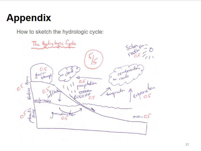
23
groundwater
water that lies beneath the ground surface, filling pores in sediments and sedimentary rocks and fractures in other types of rocks. Represents 0.6% of the hydrosphere. resupplied by slow infiltration of precipitation. Generally cleaner than surface water, accessed by wells.
24
porosity
measurement of a rocks ability to hold water
25
permeability
the capacity of a rock to transmit fluid through pores and fractures
26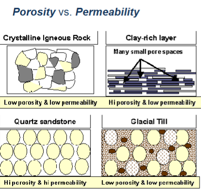
porosity v permeability
27
vadose zone
the subsurface region above the water table that is unsaturated
28
phreatic zone
the subsurface zone in which all rock openings are filled with water
29
water table
top of the saturated zone
30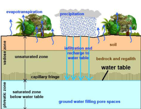
Image occlusion: name the hidden labels
31
aquifers
body of saturated rock or sediment through which water can move easily. Usually sandstone, conglomerate, sand and gravel, etc.
32
Glacier
large, long lasting mass of ice, formed on land that moves under its own weight. 75% of worlds freshwater is stored here.
33
ice sheet
a mass of glacial land ice extending more than 50,000 km^2
34
ice shelf
permanent floating ice connected to a landmass mainland. does not have an SLE.
35
Sea level equivalent
the change in global averaged sea level that would occur of a given amount of water or ice were added
36
sea ice.
frozen ocean that forms in the water.
37
glacial budgets:
zone of accumulation, zone of ablation, equilibrium line.
38
zone of accumulation:
area with perennial snow cover
39
zone of ablation
the area of ice loss by melting, evaporation, and calving.
40
equilibrium line
boundary where winter snow is lost and doesn't contribute to glacial growth. AKA: snow line
41
glacier growth and positive budget:
accumulation greater than ablation, an advancing glacier
42
glacier recedes and negative budget:
ablation exceeds accumulation, receding glacier.
43
Snow
90% air
44
granular ice
50% ice
45
firn
20-30% air
46
glacial ice
20% air as bubbles
47
plastic zone
the lower zone of a glacier that is the primary location of movement
48
rigid zone
the upper portioin of a glacier that is passively "riding along".
49
crevasse
fractures formed in the upper rigid zone during glacier flow, most often around curves.
50
calving
a form of glacier ablation where large ice chunks break off from terminus of glacier
51
ice berg
large mass of glacial ice calved into water, 90% of it is below water
52
plucking
dislodging of bedrock fragments by the freezing of basal water
53
rock flour
the production of mud, the grinding of bedrock.
54
striations
erosional lines in bedrock, indicates glacier flow direction.
55
cirque
steep-side, half-bowl-shaped recess carved into a mountain at the head of a valley carved by a glacier.
56
glacial deposistion:
till, tillite, erratic, moraine, drumlins, eskers, kettles,
57
Till:
poorly sorted, angular rock fragments transported and then deposited by a glacier. clay to boulder sized.
58
Tillite:
lithified till.
59
erratic:
an ice transported boulder
60
moraine:
glacial till that occurs as a body of unsorted sediment on or left behind by a glacier. Can be lateral, medial, or end.
61
drumlins:
shaped like an inverted spoon in the direction of glacial travel.
62
eskers:
sinuous sediment deposits at the terminus of a glacier deposited by water
63
kettles:
hole in landscape created as sediment accumulates around ice block that subsequently melts.
64
coast
all the land near the sea, including the beacj and land just inland from the beach.
65
waves:
created by wind blowing over the surface of the water. wave height is controlled by wind speed, time of wind blowing, fetch (distance over which the wind blows)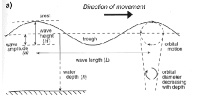
66
wave height:
the vertical distance between the crest (top) and trough (bottom) of a wave
67
wavelength:
the horizontal distance between two crests.
68
surf:
waves breaking along the shore
69
wave refraction:
waves hitting the shoreline at an angle bend and change direction to become more nearly parallet to the shoreline
70
longshore currents
refracted waves hitting the coastline at a slight angle, which pushes water parallel to the coastline.
71
longshore drift:
movement of sediment parallel to shoreline under the force of longshore currents
72
longshore drift can produce:
spits (build out points from mainland), baymouth bars (ridges of sediments that cut bays off from the ocean), tombolo (bar of sediment connecting a former island to the shore)
73
tides:
bulges in the ocean caused by the gravitational attraction of the moon and the sun on earth's ocean, bulges remained aligned with the moon.
74
spring tides:
highest tides produced by the alignment of the earth, sun, and moon.
75
neap tides:
at the first and third quarter of the moon, sun and moon are at right angles to each other.
76
sediment budgets:
the result of all the sedimentary inputs and outputs into a sedimentary environment. inputs include terrestrial supply, marine sediments from offshore, riverine sources. Outputs include transport to dunes, export to deep ocean.
77
sea level:
the height, relative to some data, of the surface of the sea as measured at a given time and place.
78
estuaries:
drowned river mouths
79
fjords:
drowned glacially cut valleys
80
beach:
strip of sediment from the low water line inland to a cliff or zone of permanent vegetation.
81
beach modification:
jetties (rockwalls along the harbor), groins (seawall things that trap sand), seawall itself, breakwaters (offshore structures that absorb large breakers.
82
deltas:
body of sediment deposited when a river or riverlike current flows into a standing water body, like a lake or sea.
83
barrier islands:
long semi straight features that run parallel to the coastline and are separated from mainland. Galveston.
84
lagoons:
shallow marine environments separated from the open sea by barrier islands.
85
reefs:
discrete carbonate structure formed either in situ or bound organic components that develop topographic relief on the seafloor. Shoal of rock, sand, coral or similar material beneath the ocean floor.
86
is coral found all over the world?
Yes! but only warm water tropical corals build reefs.
87
Coral is:
a living invertibrate organism, cousin to the jellyfish
88
two different types of coral:
reef building hermatypic, and solitary ahermatypic.
89
polyp:
animal portion of the reef, absorbs calcium carbonate.
90
corals are cnidarians, which are:
soft bodied, carnivorous, have stinging cells, and are symmetrical.
91
two life stages of a coral:
polyp and medusa.
92
nematocysts:
stinging cells that help catch food.
93
asexual reproduction in corals:
budding, or when a baby polyp will begin growing off the adult and detach when ready. New colonies cannot form.
94
sexual reproduction in corals:
spawning, they use external fertilization. can start new colonies.
95
zooxanthella:
single celled dinoflagellate algae that live in symbiosis with multiple marine invertibrates. lives in the skin of the coral. has chloroplasts.
96
how is the coral and zooxanthella symbiotic?
coral provide protection, zooxanthella provide color and get sugars, amino acids, nutrients. zooxanthella get carbon dioxide, phosphates, and nitrogen compounds.
97
habitat specifics for coral:
temperature of 73-75 D, depth of 80-230 ft, normal salt levels, need to be in light, normal sedimentation,
98
coral bleaching:
when the zymbiotic relationship between coral and zooxanthella is stresed, the corals will expel the algae.
99
coral reef structure:
primary reef framework, secondary reedf, erosion, internal sedimentation, internal cementation.
100
types of reefs:
fringing (flat, table like reefs attached to shore, hawaiian islands), barrier (parallel to shore, australia), atolls (rim lagoons, french polynesia)
101
earliest marine life
stromatolites, 3.5 bya
102
when do eukaryotes arrive in the fossil record?
2.1 bya
103
arrival of animals:
1 bya - 541 mya
104
3 domains
bacteria, archaea, eukarya
105
6 kingdoms:
eubacteria, archaeobacteria, plantae, animalia, fungi, protista
106
viscosity:
substances internal resistance to flow, increases with salinity and temp reductions.
107
surface area to volume ratio
\frac{Surface}/{Volume}
108
stenothermal/haline:
organism can withstand only small temp/salinity changes
109
eurythermal/haline:
organism can withstand a variable temp/saline changes
110
pressure:
increases at ~1kgcm^2 every 10 m of depth, deep ocecan is several hundred kgcm^2 (several tons per in^2)
111
zones in the ocean:
epipelagic mesopelagic, bathypelagic, abyssopelagic, euphotic, disphotic, aphotic.
112
epipelagic:
surface to 200 m
113
mesopelagic:
200 to 1000 m
114
bathypelagic:
1000 to 4000 m
115
abyssopelagic:
>4000 m
116
euphotic:
surface to 100 m
117
disphotic:
100 to 1000 m
118
aphotic:
>1000 m
119
primary productivity:
the rate at which organisms store energy through the formation of organic matter using energy derived from photosynthesis adn chemosynthesis
120
photosynthesis makes __% of the biomass produced
99
121
measuring primary productivity:
V=(pi r^2)(L), water samples, satellites.
122
Compensation depth for photosynthesis:
the water depth at which is so limited the net photosynthesis 0
123
renfield ratio:
the ratio of C:N:P in algae tissues, 106:16:1.
124
Eutrophication:
dead zones, the water becomes anoxic and kills marine life that do not flee.
125
how much energy goes up each trophic level?
10%
126
zooplankton:
animal plankton
127
meroplankton:
animals that spend only part of their life cycle in the plankton and the remainder in an alternate life mode.
128
icthyoplankton
planktonic eggs and larvae of fish
129
holoplankton:
all the rest of zooplankton, jellyfish and such.
130
microzooplankton:
type of holoplankton that range in size from 20-200 micrometers.
131
crustacean zooplankton:
type of holoplankton that include the copepods, amphipods, mysids, and euphausiids.
132
planktonic molluscs:
type of holoplankton that usually have shells. inlcude heteropoda, thecosomata, gymnosomata
133
gelatinous zooplankton:
type of holoplankton that include cnidaria, hydromedusae, siphonophores, etc.
134
biologic pump:
transfer of carbon and nutrients from the upper ocean to teh sea floor, mostly through particulate organic matter (POM)
135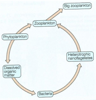
microbial loop:
136
DOM:
dissolved organic matter
137
DOC:
dissolved organic carbon